


New 3D Earth Model Pinpoints Earthquakes, Nuclear Blasts
A new 3D model of the Earth will now let scientists pinpoint the sources of earthquakes and explosions around the globe more accurately than ever, researchers say.
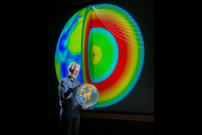
The new model of the Earth's mantle and crust from Sandia National Laboratories and Los Alamos National Laboratory is called Sandia-Los Alamos 3D, or SALSA3D. The aim of the model is to more accurately locate all types of explosions, including nuclear ones, for the U.S. Air Force and the international Comprehensive Nuclear-Test-Ban Treaty Organization (CTBTO) in Vienna.
"We want to help monitor the Earth to make sure that countries are complying with treaties they signed regarding nuclear weapons, or in the case of countries that have not signed onto such treaties, to keep up with them and know what they're up to," researcher Sandy Ballard, a geophysicist at Sandia National Laboratories, told LiveScience. [The Top 10 Largest Nuclear Tests]
Anticipating explosions
When an explosion goes off, the energy ripples through the Earth in the form of seismic waves that shift the particles in rocks and other materials back and forth tiny distances. Seismometers at U.S. and international ground monitoring stations tasked with monitoring nuclear explosions worldwide can detect these signals and home in on the locations of their sources.
SALSA3D is based on 10 million data points from 118,000 earthquakes and 13,000 current and former monitoring stations worldwide. It depends on the same modeling techniques used to detect a tumor in an MRI, except it uses seismic data and works on a global, rather than a human, scale.
Monitoring agencies can use the model to compute how earthquakes and explosions from any point on Earth might look like to their monitoring stations beforehand. Then, when it comes to calculating the location of a new event in real time, they can do so in about a second, Ballard said.
Get the world’s most fascinating discoveries delivered straight to your inbox.
"This model really improves our ability to locate earthquakes and explosions, particularly nuclear explosions," Ballard said. "If somebody tests a nuclear device, we really need to know where it is as accurately and as precisely as possible with the smallest amount of uncertainty. Using this fully three-dimensional model, we can significantly improve our ability to locate these events compared with the one-dimensional models used for decades."
Seismic distortions
This new model accounts for how seismic waves get distorted when they move through geological features such as subduction zones, perilous areas where one of the tectonic plates making up Earth's surface is diving under another.
"The biggest errors we get are close to the surface of the Earth," Ballard said in a statement. "That's where the most variability in materials is."
The scientists realized that no model is perfect. As such, they developed a way to estimate the uncertainty in each prediction SALSA3D makes, based on the uncertainty involved with analyzing each wave from a seismic event at each monitoring station.
"When you have an earthquake or nuclear explosion, not only do you need to know where it happened, but also how well you know that," Ballard said.
International test ban treaties require that on-site inspections can only occur within a 1,000-square-kilometer (about 385 square miles) area surrounding a suspected nuclear test site. In recent tests, SALSA3D was able to predict the source of seismic events over a geographical area that was 26 percent smaller than the traditional one-dimensional model and 9 percent smaller than a previous model developed jointly by Sandia, Los Alamos and Lawrence Livermore national laboratories,
"It's extremely difficult to do because the problem is so large," Ballard said. "It's mainly a computational problem — the math is not so tough, just getting it done is hard, and we've accomplished that."
'Maybe good things will come…'
So far, SALSA3D only analyzes body waves that travel through the Earth's interior. "There are also surface waves that travel on Earth's surface," Ballard said. "We'd like to incorporate that kind of data as well — the benefit of doing that is that lots of parts of Earth are not well-sampled by body waves but are sampled by surface waves."
Sandia National Laboratories has released SALSA3D's framework to other geoscientists and the public to better test models of how Earth works.
"Right now, when it comes to building models to detect these kinds of events, different monitoring agencies have trouble comparing models to each other, since they're all in different formats," Ballard said. "We did a lot of work to develop ours, and we went on to do a little extra work to make it generally accessible for others and decided to release it for free. Maybe good things will come from that."
Ballard and his colleagues will detail their findings at the American Geophysical Union meeting in San Francisco in December.
Follow us @livescience, Facebook & Google+. Original article on LiveScience.com.
