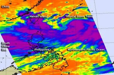
A deadly combination of monsoon rains and heavy rainfall from Tropical Storm Trami swamped the northern Philippines on Monday and Tuesday. NASA's Aqua satellite snapped an infrared image of the ferocious storm as it blanketed the capital city of Manila, where at least 15 people died in the flooding, according to news reports. More than 130,000 people were evacuated or left their homes because of the rising floodwaters, the Associated Press reported.
Trami is moving west toward northern Taiwan today (Aug. 20) at 13.8 mph (22.2 km/h), NASA said in a statement. After passing the Philippines, the storm intensified into a Category 1 typhoon (the equivalent of a hurricane), according to an update from the Joint Typhoon Warning Center. The approaching Typhoon Trami is already dropping heavy rainfall in Taiwan, prompting school closures and shutdown of some high-speed rail lines, the Associated Press reports.
Read more: ABC News
Latest Videos FromLive Science
Email Becky Oskin or follow her @beckyoskin. Follow us @livescience, Facebook & Google+.