Hurricane Isaac Makes Landfall
Get the world’s most fascinating discoveries delivered straight to your inbox.
You are now subscribed
Your newsletter sign-up was successful
Want to add more newsletters?
Delivered Daily
Daily Newsletter
Sign up for the latest discoveries, groundbreaking research and fascinating breakthroughs that impact you and the wider world direct to your inbox.
Once a week
Life's Little Mysteries
Feed your curiosity with an exclusive mystery every week, solved with science and delivered direct to your inbox before it's seen anywhere else.
Once a week
How It Works
Sign up to our free science & technology newsletter for your weekly fix of fascinating articles, quick quizzes, amazing images, and more
Delivered daily
Space.com Newsletter
Breaking space news, the latest updates on rocket launches, skywatching events and more!
Once a month
Watch This Space
Sign up to our monthly entertainment newsletter to keep up with all our coverage of the latest sci-fi and space movies, tv shows, games and books.
Once a week
Night Sky This Week
Discover this week's must-see night sky events, moon phases, and stunning astrophotos. Sign up for our skywatching newsletter and explore the universe with us!
Join the club
Get full access to premium articles, exclusive features and a growing list of member rewards.
Update 7:37 a.m. EDT Wed, Aug. 29: After stalling out over water near the coast after its first landfall, Isaac made its second landfall along the southeast coast of Louisiana just west of Port Fourchon around 2:15 a.m. CDT.
Hurricane Isaac has roared ashore just before 8 p.m. ET in Louisiana's Plaquemines parish.
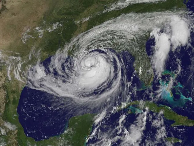
The storm came ashore as a Category 1 hurricane along the coast of southeastern Louisiana as expected. It made official landfall over a small spit of land near the mouth of the Mississippi River, the Weather Channel has reported. The eye of the storm is back over water and Isaac will make a second landfall tonight.
Isaac's path was eerily similar to that of Hurricane Katrina, which hit seven years ago tomorrow (Aug. 29). Despite the similarities between the storms, there were also considerable differences, including Isaac's comparative weakness.
As it came ashore, Isaac had winds of 80 mph (130 kph). Isaac is expected to weaken as it moves further inland and is cut off from the warm Gulf waters that fuel its convection.
Isaac will continue to dump rain as it moves further inland – rainfalls between 7 and 14 inches (18 to 36 centimeters) are expected.
Isaac became a hurricane — the fourth of the 2012 Atlantic hurricane season — less than a day before it made landfall.
Get the world’s most fascinating discoveries delivered straight to your inbox.

Andrea Thompson is an associate editor at Scientific American, where she covers sustainability, energy and the environment. Prior to that, she was a senior writer covering climate science at Climate Central and a reporter and editor at Live Science, where she primarily covered Earth science and the environment. She holds a graduate degree in science health and environmental reporting from New York University, as well as a bachelor of science and and masters of science in atmospheric chemistry from the Georgia Institute of Technology.
