This week marks the one-year anniversary of a NASA mission designed to help answer an age-old question: How salty is the sea?
The Aquarius instrument aboard the Satélite de Aplicaciones Científicas (SAC)-D is providing some of the first large-scale pictures of ocean salinity around the world, and how it changes from week to week — which influences everything from ocean circulation to the global water cycle.
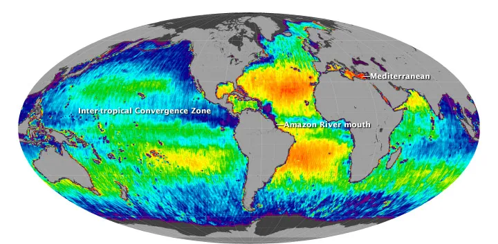
The satellite was launched on June 10, 2011. Over the last year, the instrument has sent back data showing the sometimes striking variations in salinity in the world's oceans and seas, and has also confirmed Earth-bound observations.
Latest Videos From
Oceanographers have long known that the Atlantic Ocean is saltier than the Pacific and Indian oceans, and the satellite images show the same. It has also shown that the world's longest rivers carry tremendous amounts of fresh water from land and spread plumes far into the sea. And in the tropics, extra rainfall makes equatorial waters somewhat fresher.
The satellite technically measures the "brightness temperature" of a tiny layer atop ocean waters — a slice just 0.4 inches (1 centimeter) thick. Land masses tend to be "brighter" than water, so any measurements near the coast are skewed by their proximity to land. But as the mission progresses, NASA engineers should be able to sort out the signals in the data caused by bright land, and get the true measure of salinity in coastal areas.
An overarching question in climate research is to understand how changes in the Earth's water cycle — which encompasses everything from rainfall to evaporation to river runoff and other factors — is linked to ocean circulation and climate, Gary Lagerloef, the Aquarius principal investigator, said in a statement.
The instrument is the first designed to study ocean salinity from space. It takes 300,000 measurements per month, using three sensors, for a mission that is a joint U.S.-Argentina effort.
Follow OurAmazingPlanet for the latest in Earth science and exploration news on Twitter @OAPlanet. We're also on Facebook & Google+.