


Satellite Captures Path of Destruction from New Mexico Wildfire
An environmental satellite has captured a photo of the ongoing destruction wrought by the Whitewater-Baldy Complex fire, which continues to spread since it was ignited by lightning on May 16 east of Glenwood, N.M.
As of today (June 6) it has burned 412 square miles (1,067 square kilometers) and is 22 percent contained, despite the efforts of 1,050 people actively involved in putting the fire out, according to the U.S. Forest Service. The area's rugged terrain has hampered progress, as have strong winds.
Crews are fighting the blaze in several ways. One primary method is by igniting smaller, controlled fires — both by hand and using aircraft — to create breaks to halt its progress. Several small towns in the area were evacuated, although residents were allowed back into the "ghost town" of Mogollon earlier this week. The cost of containing the fire has already surpassed $10 million, according to the New York Times.
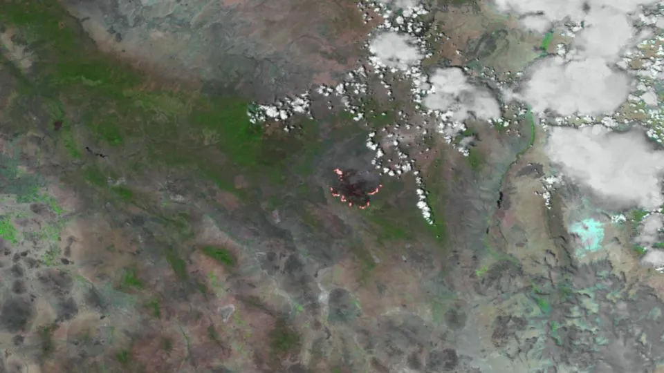
The satellite image of the smoke was taken by the VIIRS instrument aboard the Suomi NPP spacecraft on Monday (June 4). The burn scar is colored maroon, while the fire's hotspots appear in red and while on the edge of the scar.
With an abundance of downed timber of the mixed conifer in the Gila National Forest providing ample fuel, the wildfire will likely continue to spread, although firefighters continue to make small gains in battling the conflagration.
Today (June 6) in the west and northwest portion of the fire, crews focused on mopping up and putting out the previous day's burn activities to create fire breaks. In the south and southwest sections of the fire boundaries, firefighters finished prepping cabins to protect them against potential fire movement, according to the Forest Service.
Though Whitewater-Baldy is big, it currently pales in comparison to some other wildfires that have torched the continental United States. For example, last year's Wallow Fire— which spread from an unattended campfire in eastern Arizona — burned 841 square miles (2,178 square km).
Get the world’s most fascinating discoveries delivered straight to your inbox.
Before Whitewater-Baldy grew so large, New Mexico's biggest wildfire had been the Las Conchas blaze, which burned 244 square miles (632 square km) in 2011 in the northern part of the state.
Winds have carried haze from the fire as far north as Santa Fe, as far south as Las Cruces and west into Arizona, and forced the closing of the Gila Cliff Dwellings National Monument, according to the Las Cruces Sun-News.
