Even as firefighters finish containing the biggest fire in Arizona history, work is already underway to restore the forest. The first step in planning a recovery is to assess how badly the forest was burned, and satellite images like this one play a significant role.
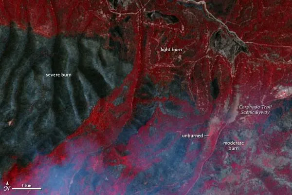
Arizonaâ??s Wallow Fire was first reported in the early afternoon of May 29, 2011. Fueled by extremely dry conditions and helped by strong winds, the fire had burned 538,048 acres of forest in the White Mountains of eastern Arizona by June 27. But as it burned, the Wallow Fire was not all consuming. This image shows areas of complete burn side-by-side with places that were only moderately or lightly burned or not touched at all.
The Advanced Spaceborne Thermal Emission and Reflection Radiometer (ASTER) on the Terra satellite acquired the image on June 21, 2011. The fire was still burning when ASTER took this image. The pale blue haze along the lower border of the image is smoke.
Latest Videos From
Satellite images such as this one are necessary in assessing damage from extremely large and/or remote wildfires. The image helps responders identify the most severely affected areas where the land may need to be stabilized to prevent further damage. Responders use these assessments to create a recovery plan.
The recovery plan for the Wallow Fire is in development, but officials are already warning of the potential for dangerous floods and landslides. As this image shows, sections of the Wallow Fire burned all stabilizing plants on steep mountain slopes. The charred soil does not absorb water, and as a result, even moderate rain may trigger floods and landslides.