It's quick and easy to access Live Science Plus, simply enter your email below. We'll send you a confirmation and sign you up for our daily newsletter, keeping you up to date with the latest science news.
The eastern Pacific hurricane season begins Tuesday, May 15th and it appears the atmosphere has jumped the gun by a day.
As AccuWeather.com Meteorologist Eric Leister recently pointed out, a system roughly 580 miles southwest of Acapulco, Mexico as a candidate for the 2012 season's first tropical cyclone in the eastern Pacific.
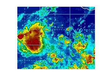
Tropical Depression One-E has formed in this area and could soon become Eastern Pacific Tropical Storm Aletta.
At 8:00 a.m. PDT, the system was located near 9.8 North and 105.9 West with sustained winds estimated near 35 mph.
We have been observing clusters of thunderstorms fluctuating in strength in the region during the past several days.
One particular cluster of storms is located within a low pressure area and remains in a favorable zone for additional development with low wind shear and sufficiently warm water.
Sign up for the Live Science daily newsletter now
Get the world’s most fascinating discoveries delivered straight to your inbox.
At some point over the next couple of days we may have the first tropical storm of the season in the waters surrounding the Americas, provided a low level circulation continues to evolve.
(Image credit: Accumweather.com)
According to Tropical Weather Expert Dan Kottlowski, "Investigations of the system, including satellite microwave technology, over this past weekend proved to be inconclusive."
The technology provides the ability to detect low-level circulation of a storm system through thick cloud cover and where no surface or aircraft observations are present.
"During this past weekend, the area of disturbed weather had a circulation in the mid-levels of the atmosphere, but not the low levels," Kottlowski said.
(Image credit: Accumweather.com)
In order for a system to be truly tropical and develop as such, it needs to have a circulation in the lower levels of the atmosphere.
This process was beginning today.
Steering flow will direct the system almost due west, away from Mexico and Central America.
(Image credit: Accumweather.com)
The clock is ticking on the favorable zone for further development and survival for the system.
"After a couple of days the system would encounter cooler water and likely significant wind shear," Kottlowski said.

 Live Science Plus