















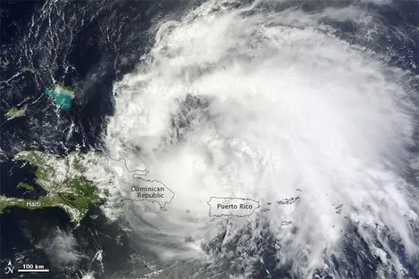
The first hurricane to threaten the United States this year brings the potential of gale-force winds, soaking rains and flooding to a broad swath of the U.S. Eastern Seaboard.
Last Saturday evening, an Air Force reserve hurricane hunter aircraft investigating a large tropical wave east of the Lesser Antilles in the North Atlantic Ocean found a small low-level circulation center sporting sustained (steady) winds of 50 mph (80 kph). These wind speeds took it above the threshold for a tropical storm, making it the ninth of the season; it was christened "Irene." Slowly strengthening as it moved to the north of Puerto Rico, Irene's winds increased to 75 mph (121 kph) early on Monday, making it the season's first hurricane.
Early today (Aug. 23), the center of Hurricane Irene was located just to the north of the island of Hispaniola, which is home to the nations of the Dominican Republic and Haiti. With sustained winds of 100 mph (161 kph) near its center, the storm currently ranks as a Category 2 on the five-point Saffir-Simpson scale. Irene was moving to the west-northwest at 10 mph and is projected to curve on a more northwest trajectory through the Bahamas during Tuesday and Wednesday, all the while continuing to strengthen to "major" hurricane status (with winds exceeding 115 mph, or 185 kph).
Early on Thursday, the latest intensity forecast from the National Hurricane Center (NHC) in Miami, indicates Irene could max out at sustained winds of 135 mph (217 kph) making it a very strong Category 4. "Irene is forecast to become a larger than average hurricane," said Stacy Stewart, an NHC Senior Hurricane Specialist. [Related Video: Hurricane Irene Is Born]
And after that, Irene could take aim at the Eastern United States.
East Coast march?
Based on a consensus of computer models, the center of Hurricane Irene could skim offshore to the east of Florida during Thursday and Friday before making landfall somewhere between Charleston, S.C., and Wilmington, N.C., early Saturday. After that, the storm is expected to pick up speed and shift northeast, reaching southern New England by early next Monday.
Get the world’s most fascinating discoveries delivered straight to your inbox.
But any long-range outlook concerning the future course of a hurricane is always chancy, and the hurricane's ultimate course could diverge significantly.
Based on the latest forecast guidance as well as the climatology of other tropical systems over the past several decades that have taken similar tracks, it appears that wherever Irene eventually goes it would slowly accelerate after coming ashore and then turn toward the northeast.
Possible 'drownpours'
Irene is expected to lose some of its intensity after it moves inland, but whether it will still be a well-defined tropical cyclone or a disorganized mélange of wind and rain when it reaches southern New England early next week is open to debate. No matter: All tropical systems tend to have their moisture wrung out as they move inland from over open waters. Meteorologists call this "frictional drag" and the effect is analogous to squeezing a very damp sponge.
As such, it appears that most of the East Coast is in for a soaking. Around the region in the Carolinas where Irene may first make landfall, excessive rainfall amounts of at least 6 to 12 inches (15 to 30.5 cm) seem a good bet, while places farther to the north and east that are along and near Irene's track have a chance of getting drenched by perhaps 3 to 6 inches (7.6 to 15 cm) of showery, heavy rains. Embedded strong-to-severe thunderstorms as well as a few isolated tornadoes are also a possibility with such tropical systems.
It is still rather uncertain just how close a return to the coast Irene would make after its predicted inland passage through the Carolinas. If it follows a track along or immediately adjacent to the shoreline, coastal areas of the Northeast will be exposed to more wind and flooding than if the storm tracked farther inland.

Locked in a channel
Two forces are likely to keep the storm near the East Coast. One is a large subtropical ridge of high pressure over the Atlantic Ocean extending westward that will act like an atmospheric barrier to prevent Irene from taking a track to the east out to sea. The other player in Irene's future movement is the development of a large trough a "buckling" of the mid-to-upper atmospheric wind field along the East Coast. [Related: Which U.S. Cities Are Most Vulnerable to Hurricanes?]
So the hurricane will be locked into something analogous to an atmospheric channel and will be forced to sweep north-northeast in an arc somewhere along the Atlantic Seaboard.
The biggest uncertainty is the precise timing of the development of the atmospheric trough. If it develops quickly, Irene theoretically could move on an inland track after making a Saturday landfall over the Carolinas, taking it roughly parallel to, but not quite approaching, the foothills of the Appalachians.
Conversely, if the trough takes a longer interval of time to develop, Irene could take a path more closely aligned with the coastal plain of the Eastern United States; a region populated by 50 to 60 million people (based on the 2010 census). Right now, that latter scenario appears to be more likely.
According to David Roth, lead forecaster at NOAA's Hydrometeorological Prediction Center at Camp Springs, Md., "Irene should round the western periphery of the subtropical ridge across the western subtropical Atlantic along a parabolic track ... with the Outer Banks of North Carolina and Cape Cod most at risk at this time."
For the latest projected track of Irene from the National Hurricane Center, see: http://tinyurl.com/3tx4qal.
High tides
Another factor to take into consideration is the strong onshore winds that can be generated by an approaching tropical system. While wind gusts of hurricane force might be confined to an area within 40 or 50 miles of the center of the storm, winds of full gale force 39 mph or higher might be felt 150 to perhaps 200 miles from the center. Although the winds associated with a hurricane start to diminish soon after the storm center moves over land, strong "squally" type winds can continue to be a factor long after a tropical system has fully moved over land. Coastal areas in particular should be alert to the potential of higher-than-normal tides which could lead to coastal flooding as well as beach erosion.
Astronomically speaking, even without a major coastal storm, tides will be running higher than normal.
On Sunday night the moon will be at new phase, meaning that the effects of the sun, moon and Earth in a straight line (called a "syzygy") will result in "spring" tides, which means the range of the tides from low to high will be at its maximum, only accentuating the potential for flooding and erosion problems, especially for the Northeast.
Another active year
With Irene attaining tropical storm status last Saturday, this makes the 2011 Atlantic hurricane season the third earliest to have nine named storms, trailing behind the years 2005 and 1936. Considering that those two years saw a total of 28 and 16 tropical cyclones respectively, this suggests that 2011 will also be an unusually active tropical season. Last year there were 19 tropical cyclones, 12 of which became hurricanes; four of these reached Category 4 status, the strongest being "Igor" with sustained winds clocked at 135 mph.
Yet interestingly, despite 2010 being a very active year for hurricanes, all 12 of those storms somehow avoided making a landfall in the United States. In fact, the last hurricane to impact the U.S. was back in September 2008 when Ike hit near Galveston, Texas. So Irene will likely soon break a nearly three-year interval in which no hurricanes have crossed the U.S. mainland.
And here's another oddity: Never before did we have to wait until the ninth named tropical system to finally get a storm that attained hurricane status.
