The National Oceanic and Atmospheric Administration's (NOAA) GOES-11 satellite captured a movie of Hurricane Dora's intensification in the eastern Pacific over the last few days that clearly shows the massive storm's developing eye.
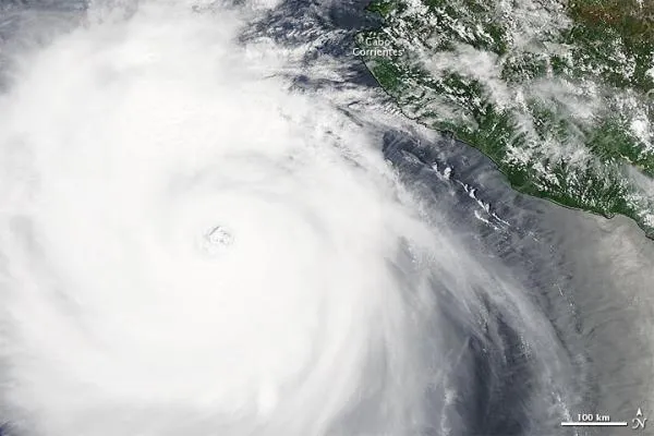
Satellites provide a bird's eye view of a hurricane's eye , and NASA noticed Hurricane Dora's cloud-free center as the storm strengthened to near Category 5 status (the highest hurricane classification) on July 21. The strongest thunderstorms and convection completely surrounded the eye.
The Geostationary Operational Environmental Satellite called GOES-11 provides continuous visible and infrared imagery of the western United States and eastern Pacific Ocean basin from its position in space. GOES-11 images were compiled into a movie that runs from July 19 at 10:30 a.m. EDT when Dora was a tropical storm, to July 21 at 10:30 a.m. EDT, when Dora was a major hurricane .
Latest Videos From
The animation includes sped-up infrared and visible frames of data that were captured every 15 minutes from the GOES-11 satellite and squeezed down to 26 seconds. [Watch the animation here.]
{brightcove CMS_LS_15176}
At 11 a.m. EDT on July 21, Dora's maximum sustained winds were near 155 mph (250 kph), right on the brink of Category 5 hurricane status. Fortunately, Dora's center is remaining at sea, about 240 miles (390 km) south-southwest of Cabo Corrientes, Mexico, and will continue to remain at sea as it moves to the northwest near 12 mph (19 kph). It is expected to continue in that direction for the next couple of days and slow down.
Dora is far enough off the coast that there are no watches and warnings over land. However, Dora is sending large ocean swells against the beaches of western Mexico today (July 22). Those large, rough ocean swells will affect the coast over the next couple of days, and will also begin affecting the southern Baja California coast.
In the Atlantic basin, Tropical Storm Cindy is about 730 miles (1,175 kilometers) northwest of the Azores islands, with maximum sustained winds of up to 50 mph (85 kph).
The former Tropical Storm Bret has been downgraded to a low pressure area, about 375 miles (605 km) north of Bermuda, with winds of up to 35 mph (55 kph).

 Live Science Plus