Tropical Storm Bret to Wind Down
Get the world’s most fascinating discoveries delivered straight to your inbox.
You are now subscribed
Your newsletter sign-up was successful
Want to add more newsletters?
Delivered Daily
Daily Newsletter
Sign up for the latest discoveries, groundbreaking research and fascinating breakthroughs that impact you and the wider world direct to your inbox.
Once a week
Life's Little Mysteries
Feed your curiosity with an exclusive mystery every week, solved with science and delivered direct to your inbox before it's seen anywhere else.
Once a week
How It Works
Sign up to our free science & technology newsletter for your weekly fix of fascinating articles, quick quizzes, amazing images, and more
Delivered daily
Space.com Newsletter
Breaking space news, the latest updates on rocket launches, skywatching events and more!
Once a month
Watch This Space
Sign up to our monthly entertainment newsletter to keep up with all our coverage of the latest sci-fi and space movies, tv shows, games and books.
Once a week
Night Sky This Week
Discover this week's must-see night sky events, moon phases, and stunning astrophotos. Sign up for our skywatching newsletter and explore the universe with us!
Join the club
Get full access to premium articles, exclusive features and a growing list of member rewards.
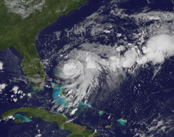
A NASA satellite caught a glimpse of Tropical Storm Bret as it swirled over the Bahamas.
Tropical Storm Bret was born in the northwestern Bahamas and after intensifying earlier this week, is now beginning to weaken. Bret is the second named storm (tropical storms and hurricanes receive names) to form during the 2011 Atlantic hurricane season, which began on June 1. Tropical Storm Arlene formed in the Gulf of Mexico in late June. NASA's GOES-13 satellite captured a series of images of the storm blowing up over the Atlantic several days ago. Before it was named Bret, the storm was called Tropical Depression 2, which formed at 5 p.m. EDT on July 17. At that time it had maximum sustained winds near 35 mph (56 kph) and was just 100 miles (161 kilometers) northwest of Great Abaco Island. The Abaco Islands are located in the northern Bahamas and are made up of the main islands of Great Abaco and Little Abaco with many smaller islands called "cays."
{brightcove CMS_LS_15118}
On July 18 at 8 a.m. EDT, Tropical Depression 2 strengthened into Tropical Storm Bret. Maximum sustained winds were up to 50 mph (80 kph). At that time, Bret was just 65 miles (105 km) north-northwest of Great Abaco Island (and about 200 miles (322 km) off the eastern Florida coast), trudging along at 3 mph (5 kph) to the northeast. The following video shows Bret as it powered up over warm Atlantic Ocean waters.
Bret is now expected to weaken and stay well off-shore of the southeastern United States.
Despite the slow start, the 2011 Atlantic hurricane season has been predicted to be a doozy. The U.S. National Oceanic and Atmospheric Administration (NOAA) has predicted between six to 10 hurricanes, three to six major hurricanes (those with winds of 111 mph (179 kph) or higher) and 12 to 18 named storms.
Get the world’s most fascinating discoveries delivered straight to your inbox.

