


Tropical Storm Bret Seen From Space
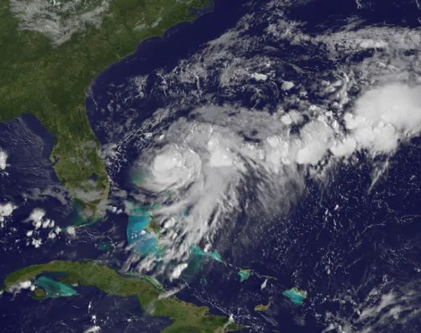
A NASA satellite caught a glimpse of Tropical Storm Bret as it swirled over the Bahamas.
Tropical Storm Bret was born in the northwestern Bahamas and continues to strengthen. Bret is the second named storm (tropical storms and hurricanes receive names) to form in the Atlantic basin so far this season. Tropical Storm Arlene formed in the Gulf of Mexico in late June. The Geostationary Operational Environmental Satellite, called GOES-13, captured the imaged. GOES-13 provides continuous visible and infrared imagery of the eastern United States and Atlantic Ocean basin from its position in space. GOES satellites are operated by the U.S. National Oceanic and Atmospheric Administration. Before it was named Bret, the storm was called Tropical Depression 2, which formed at 5 p.m. EDT on July 17. At that time it had maximum sustained winds near 35 mph (56 kph) and was just 100 miles (161 kilometers) northwest of Great Abaco Island. The Abaco Islands are located in the northern Bahamas and are made up of the main islands of Great Abaco and Little Abaco with many smaller islands called "cays." On July 18 at 8 a.m. EDT, Tropical Depression 2 strengthened into Tropical Storm Bret. Maximum sustained winds were up to 50 mph (80 kph). At that time, Bret was just 65 miles (105 km) north-northwest of Great Abaco Island (and about 200 miles (322 km) off the eastern Florida coast), trudging along at 3 mph (5 kph) to the northeast. Minimum central pressure is 1001 millibars. A tropical storm warning is in effect for Grand Bahama Island and the Abaco Islands in the northwest Bahamas. As a result, the northwestern Bahamas are under the gun for the greatest impacts from Bret. Rainfall could reach between 2 and 4 inches (5 and 10 centimeters), while winds can reach tropical storm-force today. Those winds should diminish tonight as Bret pulls away. Beach goers will have stay away from the ocean as locally high surf conditions are expected along northern and western facing beaches today.
Despite the slow start, the 2011 Atlantic hurricane season has been predicted to be a doozy. The U.S. National Oceanic and Atmospheric Administration (NOAA) has predicted between six to 10 hurricanes, three to six major hurricanes (those with winds of 111 mph (179 kph) or higher) and 12 to 18 named storms.
Get the world’s most fascinating discoveries delivered straight to your inbox.
