NASA satellite data shows Typhoon Ma-on soaking Guam, and the National Weather Service office there has issued an urban and small stream flood advisory for all of Guam until 2 a.m. CHST (local time) and a coastal hazard message and small craft advisories because of high waves and gusty winds.
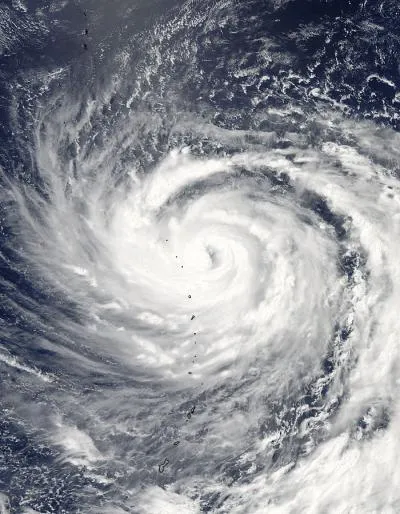
Over the last couple of days, NASA satellite data from both the Tropical Rainfall Measuring Mission (TRMM) and Atmospheric Infrared Sounder (AIRS) that flies aboard Aqua detected powerful thunderstorms within Ma-on. Those thunderstorms contained heavy rainfall, falling at a rate of 2 inches/50 mm per hour. As NASA's Aqua satellite flew over Ma-on on July 14 (11:30 p.m. EDT on July 13), the Moderate Resolution Imaging Spectradiometer (MODIS) instrument captured a visible image of Typhoon Ma-on moving over the Northern Mariana Islands.
At 1500 UTC (11 a.m. EDT/1 a.m. Guam local time) on July 14, Typhoon Ma-on had maximum sustained winds near 95 knots (109 mph/175 kmh). It was located over the northern Marianas islands, about 250 nautical miles southeast of Iwo To, Japan near 20.3 North and 144.5 East. It was moving west near 11 knots (13 mph/20 kmh).
Latest Videos From
The National Weather Service flood advisory for July 14 at 11 a.m. Eastern Daylight Time (1 a.m. local time/Guam on July 15) noted that "additional rainfall amounts of 1 to 2 inches are possible during the next several hours. Recent heavy rains have left the ground saturated."
High surf conditions are also expected in Guam, Rota, Tinian and Saipan over the next several days. At 3:50 p.m. CHST (local time in Guam) on July 14 the National Weather Service (NWS) also issued a high surf advisory that will remain in effect through 6 a.m. (local time) on Sunday, July 17 as Ma-on passes through the region. The NWS advisory states that "Surf will build to hazardous at 7 to 9 feet along west facing reefs tonight and Friday. Surf will peak at 9 to 11 feet Friday night and Saturday, and should fall below 9 feet on Sunday." Beaches and exposed reefs are places to avoid through the advisory period, especially those facing the west as Ma-on continues to move in that direction. Rip currents are also possible.
There is also a small craft advisory in effect for the coastal waters of Guam, Rota, Tinian and Saipan until 6 p.m. (local time) Sunday as seas are expected to rise to 10 to 12 feet accompanied by winds between 20 and 25 knots (23-29 mph/37-46 kmh) through Saturday night.

 Live Science Plus