Satellites Capture Quick Rise & Fall of Tropical Storm Calvin
Get the world’s most fascinating discoveries delivered straight to your inbox.
You are now subscribed
Your newsletter sign-up was successful
Want to add more newsletters?

Delivered Daily
Daily Newsletter
Sign up for the latest discoveries, groundbreaking research and fascinating breakthroughs that impact you and the wider world direct to your inbox.

Once a week
Life's Little Mysteries
Feed your curiosity with an exclusive mystery every week, solved with science and delivered direct to your inbox before it's seen anywhere else.

Once a week
How It Works
Sign up to our free science & technology newsletter for your weekly fix of fascinating articles, quick quizzes, amazing images, and more

Delivered daily
Space.com Newsletter
Breaking space news, the latest updates on rocket launches, skywatching events and more!

Once a month
Watch This Space
Sign up to our monthly entertainment newsletter to keep up with all our coverage of the latest sci-fi and space movies, tv shows, games and books.

Once a week
Night Sky This Week
Discover this week's must-see night sky events, moon phases, and stunning astrophotos. Sign up for our skywatching newsletter and explore the universe with us!
Join the club
Get full access to premium articles, exclusive features and a growing list of member rewards.
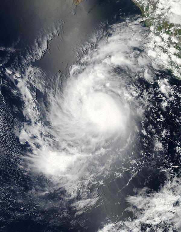
NASA satellites watched Tropical Storm Calvin become a hurricane on July 8 and weaken quickly to a remnant low pressure area by yesterday (July 10).
Tropical Storm Calvin strengthened into a hurricane around 5 p.m. EDT on Friday, July 8 with maximum sustained winds near 75 mph (120 kph). At that time it was located about 340 miles (550 kilometers) south-southwest of Cabo Corrientes, Mexico.
On July 8, NASA's Aqua satellite passed over Tropical Storm Calvin and captured visible and infrared images of the storm. These images showed strong thunderstorms developing within Calvin, and indicated that it was a well-organized and strengthening tropical storm.
July 9, Calvin's winds weakened below hurricane strength to 57 mph (93 kmh). By July 10 at 0300 UTC (July 9 at 11 p.m. EDT), Calvin's maximum sustained winds were down to 34 mph (55 kmh), relegating it down to tropical depression status.
By July 11 at 8 a.m. EDT Calvin had degraded further as the low moved into cooler sea surface temperatures. Sea surface temperatures of at least 80 degrees Fahrenheit (26.6 degrees Celsius) to maintain the strength of a tropical cyclone, a term that encompasses tropical storms, hurricanes and typhoons.
All signs of deep, strong convection (rapidly rising air that forms the thunderstorms that would power it) are gone on satellite imagery. Its center was just west of Isla Clarion.
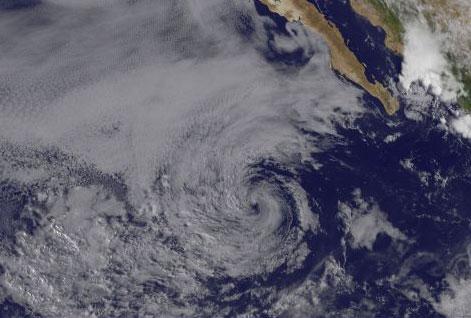
Visible imagery from the GOES-11 satellite at 1445 UTC (10:45 a.m. EDT) on July 11 shows the remnants of Calvin as a swirl of clouds in the eastern Pacific Ocean, several hundred miles off the western Mexico coastline. The low is expected to dissipate sometime on Tuesday (July 12).
Get the world’s most fascinating discoveries delivered straight to your inbox.
Calvin is the third named storm to form in the eastern Pacific this season. Only one named storm (tropical storms and hurricanes receive names) has formed in the Atlantic basin so far this season. Tropical Storm Arlene made landfall near Cabo Rojo in Veracruz, Mexico on June 30.
 Live Science Plus


