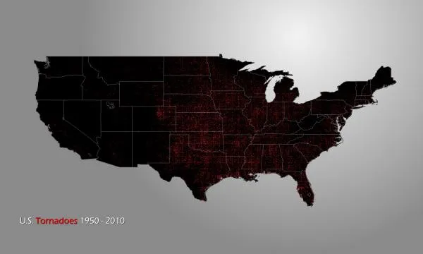
A new map shows every tornado recorded in the United States since record keeping began in 1950.
Tornadoes form year-round and all over the world, but the United States is the leader of the twister pack. The map's red dots mark each of the nearly 60,000 tornadoes that have been recorded around the country over the last 60 years.
The dots cover the famous Tornado Alley and the lesser known, but deadlier Dixie Alley . Tornadoes have touched down in every state, including three in Alaska and 28 in Hawaii (not shown).
Latest Videos From
Thousands of tornadoes strike the United States each year. Tornado season typically starts in March and hits its stride from May to June, though it's possible for tornadoes to pop up during any time of the year (November is often called the second tornado season ). [Infographic: Tornado! An Inside Look at Tornado Season ]
Tornadoes can strike anywhere at any time, day or night a tornado hit New York City at night in September last year.
The U.S. tornado map plots all of the recorded tornadoes from Jan. 1, 1950 to Dec. 31, 2010, using data from the National Climatic Data Center a total of 58,398 events.
Tornado Alley has the highest concentration. It is bordered by the Dakotas to the north, the Gulf Coast to the south, the Rocky Mountains to the west and the Appalachian Mountains to the east.
Southeast of Tornado Alley is Dixie Alley, home to the deadliest tornadoes. Dixie Alley spreads from the Lower Mississippi Valley to the Upper Tennessee Valley, including Arkansas, Mississippi, Louisiana, Alabama, Georgia and the Florida panhandle.
Textbook tornadoes form in the United States where warm, moist Gulf of Mexico air collides with cool, northern air, creating massive storms.
Click here for a high-resolution map.
Email OurAmazingPlanet staff writer Brett Israel at bisrael@techmedianetwork.com. Follow him on Twitter @btisrael.