


How a Storm Became Big Enough to Span the Atlantic
There is currently a massive storm churning over the Atlantic that spans the entire ocean basin, stretching all the way from Canada to Europe, and from Greenland to the Caribbean.
It's the same weather system that brought a massive spring blizzard to much of the United States and Canada earlier this week (on Tuesday (March 26), 44 of 50 states had some snow on the ground), and which has now ballooned in size, according to Jason Samenow, chief meteorologist with the Washington Post's Capital Weather Gang.
Robert Oszajca, lead forecaster for the National Weather Service's Ocean Prediction Center, explained that the storm got this big by merging with several low-pressure systems that were hanging out over the Atlantic Ocean. The merging weather systems gave it more power, which was accentuated by a gradient between warm moisture from the southeast, delivered by the Gulf Stream, and frigid air from the north. This intensified the storm, causing it to spin, elongate and grow in size, Oszajca told OurAmazingPlanet.
Normally, the system would have drifted into Europe several days ago. However, a high-pressure system over Greenland blocked the low-pressure system's advance, which allowed it to strengthen further, fed by cold air from the north. This created winds (which move from high pressure to low pressure) up to 75 mph (120 km/h), equivalent to a Category 1 hurricane, Oszajca said.
"We're impressed with the size of this storm," he said. Nevertheless, storms this big form about once or twice every winter.
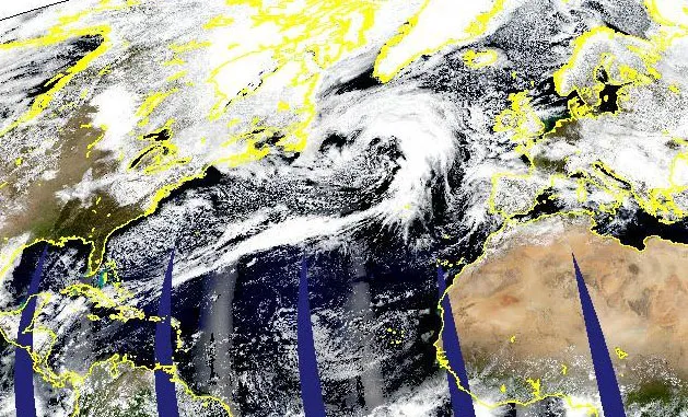
The storm, which looks like a large comma whose tail stretches into the Caribbean, ranges from Eastern Canada all the way to Spain and north to Greenland. It has created waves up to 42 feet (13 meters) high, Oszajca said.
The storm has already begun to weaken, however, as the high-pressure "blocking" system to the north has eased. Oszajca said the central low-pressure system that has powered the storm will soon break up into several separate centers, and the storm will fragment before hitting Portugal in about four days. The storm isn't expected to be very intense by the time it reaches Europe, he added.
Get the world’s most fascinating discoveries delivered straight to your inbox.
Email Douglas Main or follow him @Douglas_Main. Follow us @OAPlanet, Facebook or Google+. Original article on LiveScience's OurAmazingPlanet.
