
 Live Science Plus


Wall of Wind, Rain Sweeping Across Eastern US
This article was provided by AccuWeather.com.
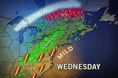
A wall of rain and wind crossing the Appalachians during the day Wednesday will reach the East Coast and the I-95 corridor during the evening hours.
The weather conditions accompanying a front will not only mark an end to the brief warmth but can also cause a slew of travel problems. The front has had a history of severe weather over the Mississippi, Ohio and Tennessee valleys.

A period of drenching, blinding rain will push from west to east, crossing the Appalachian Mountains, the eastern Great Lakes and the upper Gulf Coast region during the afternoon.
There is the potential for 1.00 to 2.00 inches of rain over a several-hour period. Combined with the terrain in the mountains and the frozen ground over the eastern Great Lakes region, rapid runoff can also lead to flash and small stream flooding.
This is enough rain to cause urban flooding problems in Pittsburgh, Buffalo, Atlanta, Charlotte, Roanoke, Scranton, Washington, D.C., Charleston, S.C., Philadelphia, New York City, Albany, Boston, Raleigh and Norfolk, Va.

This map shows the greatest potential for severe thunderstorms. However, intense rain and locally damaging wind without thunder can occur northward into upstate New York and much of New England as well.
Get the world’s most fascinating discoveries delivered straight to your inbox.
The rain will hit during the evening rush hour along much of the I-95 corridor from New Jersey to South Carolina. The rain will be heavy enough to cause sudden low visibility, especially when combined with strong wind gusts. The gusts will range from 40 to 50 mph in many locations. In some coastal areas and over the ridges, gusts can reach 60 mph.
The worst of the rain and wind will reach the New York City area and Jacksonville, Fla. during Wednesday night and then central and eastern New England overnight Wednesday into the first thing Thursday morning.
The winds can be strong enough to down tree limbs and cause sporadic power outages.
Motorists and those with flights from the Appalachians to the Atlantic coast should expect delays to build into the evening hours as the rain and high winds roll eastward. The intensity of the storms is forecast to diminish before reaching central Florida.

The rain and wind mark the first of two pushes of colder air. The first will erase the record warmth Wednesday night in the Appalachians and the East Coast on Thursday. The second will bring two to three days of arctic chill beginning Thursday in the Appalachians and the upper East Coast by Friday. Cooler weather will settle over the Deep South.
For those wondering about spring. AccuWeather.com has released its forecast for the upcoming season.
AccuWeather.com. All rights reserved. More from AccuWeather.com.
With much of the country experiencing an unseasonably warm winter, fears of climate change come to mind. See how well you understand recent weather, climate and the difference between them.
Weather vs. Climate Change: Test Yourself
