
 Live Science Plus


Northeast Forecast: Storm Break Needed; On the Way
This article was provided by AccuWeather.com.
What Sandy-ravaged and snowstorm-numbed areas of the Northeast need now is a break and it seems the atmosphere will oblige.
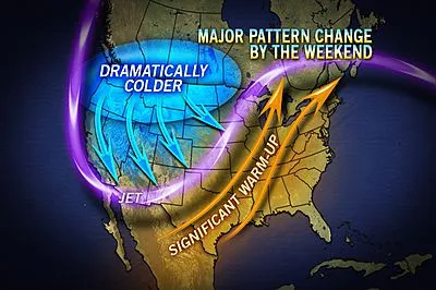
Warm air that has been building over the West and Plains this week will slosh eastward for a several-day stint beginning this weekend and continuing into the first part of next week.

The break from the storms, rain and snow will help crews, families and individuals clean up and catch up. Or, at the very least, give people one less item of their dozens of things to worry about.
Temperatures in the I-95 corridor will rebound into the 50s to near 60 on Saturday then well into the 60s Sunday and Monday. Temperatures could make a run at 70 in some locations Sunday, especially in the Baltimore/Washington, D.C., area.
Most days will bring at least partial sunshine.
Farther northwest from upstate New York to northern New England, the transition to warmer weather will run into brief resistance in the form of clouds and spotty rain for a time spanning Saturday into Saturday night.
Get the world’s most fascinating discoveries delivered straight to your inbox.

The next round of unsettled weather is slated for Tuesday as a cold front arrives with showers and perhaps a thunderstorm. The day will start out with record-challenging warmth but will finish much colder in many areas along the East coast.
While rain would simply end followed by clearing along the Atlantic coast Tuesday, the cold air could catch up to the rain rather quickly in parts of the Appalachians, perhaps bringing a brief period of snow at the tail end.
The storm responsible for the warmup and the inevitable cooldown next week will bring blizzard conditions to portions of the northern Rockies and Plains and the potential for severe thunderstorms from the Upper Midwest to Texas this weekend.
AccuWeather.com. All rights reserved. More from AccuWeather.com.
The only sure thing about weather forecasts is that they’re wildly different all over the planet. Test your knowledge on the wild ranges in temperature, precipitation and more.
Extreme Weather Facts: Quiz Yourself
