
 Live Science Plus


First Snowflakes Possible West Virginia to Maine
This article was provided by AccuWeather.com.
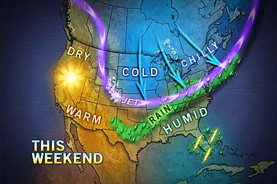
Just days after parts of the northern Plains got their first snowfall, portions of the interior Northeast could have their first snowflakes of the season later this weekend.
The storm that brought heavy snow from Montana to northwestern Minnesota is not heading in the Northeast's direction. However, a weak system that may bring Denver its first snow of the season Saturday is forecast to head toward the Atlantic coast by Sunday.

Colder air will push into the eastern Great Lakes and the Appalachians during Saturday. The chill will then filter to the Atlantic coast during Sunday and Sunday night.
It will not snow with this particular system in the I-95 cities from Washington, D.C., to New York City and Boston. It will not even snow in most other low elevations across the interior including Pittsburgh, Rochester and Roanoke. A period of rain or a couple of brief showers are forecast for these areas.
However, there is a chance that wet snowflakes will mix in Sunday afternoon over the high ground in parts of West Virginia, western Maryland, northwestern Virginia, northern and western Pennsylvania and western New York before drying out. There is a slight chance of a light coating of snow on non-paved surfaces in these areas.
During Sunday night, with the assistance of falling temperatures after sunset, it could get cold enough fast enough for more than just a few snowflakes over the high ground in northern upstate New York, Vermont, New Hampshire and northwestern Maine. There is an outside chance of a couple of inches of snow on non-paved surfaces in these areas.
Get the world’s most fascinating discoveries delivered straight to your inbox.
There is also a chance of wet snowflakes mixing in at the tail end in the Catskills, Berkshires and perhaps the Poconos Sunday evening.
The system moving through will not be an intense storm, but rather what meteorologists call a flat wave of low pressure.
The second of two flat waves is forecast to travel from West Virginia and Virginia to off the coast of southern New England Sunday/Sunday night.
The wave could have trouble producing much precipitation where it is cold enough to snow, hence the uncertainty at this point about snowfall. It could just as easily rain for a bit and end or do nothing at all with dry air winning out. Updates will follow on AccuWeather.com.
The advancing cold air will mark an end to the growing season for many locations from the Midwest to the Appalachians, where nighttime lows early next week are forecast to dip into the 30s and even the 20s.
A bit of frost can reach into some of the northern and western suburbs of the major I-95 cities.
© AccuWeather.com. All rights reserved. More from AccuWeather.com.
The weather is getting stranger, right? Well, for the most part no, scientists say, but humans often think so when a strange event does occur. So here’s your chance to prove how much you known about weather oddities.
Weird Weather: One Strange Quiz
