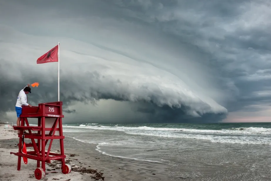
University of Central Florida photography student Jason Weingart took this photo of a shelf cloud at the leading edge of a thunderstorm, in Ormond Beach, Fla., on May 15, 2012.
NASA recently put out a call for photographers to send in their best images of extreme weather for a photo contest, and they definitely got some mind-blowing entries.
NASA judges voted for the top five images, which are featured on the website of the agency's Precipitation Measurement Missions website.
The purpose of the contest was to highlight NASA's Global Precipitation Measurement mission, an international satellite mission that studies Earth's water and energy cycles. Its goal is to improve the forecasting of extreme weather.
The winning image was taken by Brian Johnson, a storm-chasing photographer, near Wichita, Kan., on May 30. His image, which is a panorama stitched together from multiple photos, shows a low-elevation, wedge-shaped cloud known as a shelf cloud forming over a freshly cut wheat field. Shelf clouds often have damaging winds underneath them and form just ahead of strong thunderstorms.
The winning image was taken by Brian Johnson, a storm-chasing photographer, near Wichita, Kan., on May 30, 2012.
(Image credit: Brian Johnson)
University of Central Florida photography student Jason Weingart also took a photo of a shelf cloud at the leading edge of a thunderstorm, in Ormond Beach, Fla., on May 15. Despite a severe thunderstorm warning from the National Weather Service, Weingart drove to the beach in time to get a photo of the cloud and the lifeguard signaling surfers to come in from the water.
University of Wisconsin atmospheric scientist Grant Petty took his photo while on a farm with a photography club to document farm life in Dane County, Wis., on May 22, 2011. But his interest turned to the sky, where an impressive thunderstorm was building up several miles away. "This is one of many examples of how a completely unplanned photo wound up being among my best," he was quoted by NASA as writing.
University of Wisconsin atmospheric scientist Grant Petty took this photo while on a farm in Dane County, Wis., on May 22, 2011.
(Image credit: Grant Petty)
Not everybody had to leave their home to capture an awesome picture. Arlington, Va., resident Brian Allen took a shot of a lightning storm over Washington, D.C., from his apartment on Sept. 1, 2012.
Sign up for the Live Science daily newsletter now
Get the world’s most fascinating discoveries delivered straight to your inbox.
Arlington, Va., resident Brian Allen took a shot of a lightning storm over Washington, D.C., from his apartment on Sept. 1, 2012.
(Image credit: Brian Allen)
The final image was shot by Meggan Wood on July 5, 2011, in Maricopa, Ariz. She caught a picture of wind whipping up dust just before it engulfed her car, in which she took shelter.
For the science geek in everyone, Live Science offers a fascinating window into the natural and technological world, delivering comprehensive and compelling news and analysis on everything from dinosaur discoveries, archaeological finds and amazing animals to health, innovation and wearable technology. We aim to empower and inspire our readers with the tools needed to understand the world and appreciate its everyday awe.