


Why Did Isaac Take So Long to Become a Hurricane?
Tropical Storm Isaac has now officially become Hurricane Isaac, the National Hurricane Center announced this afternoon (Aug. 28).
This strengthening had been expected for more than 24 hours, however — so why did it take so long?
Tropical Storm Isaac was still intensifying early yesterday (Aug. 27) when it encountered a system of dry air, said Tim Schott, a hurricane specialist with the National Oceanographic and Atmospheric Administration. The dry air was sucked into the cyclone and prevented the eye wall (the border surrounding the cyclone's center, or eye) from forming, a key step in a storm's intensification, he told OurAmazingPlanet.
It's also a large storm, with tropical storm force winds extending for nearly 200 miles (320 kilometers). Larger storms sometimes do not intensify as quickly as smaller, more compact cyclones, Schott said.
Furthermore, forecasters still do not understand all the physics that control how or why hurricanes intensify, Schott said.
But whether or not it passed the hurricane threshold doesn't really matter, he said — either way it would be a very large system that will have wide-ranging effects. "Everybody likes to put everything into neat little boxes, but it doesn't matter that it's intensified from 70 to 75 miles per hour. The difference is really not very consequential."
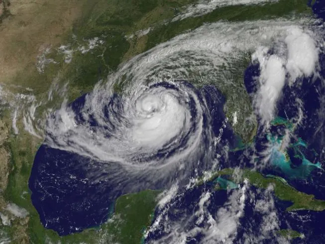
The cyclone finally achieved hurricane strength this afternoon and currently has winds of 75 mph (120 kph), just over the hurricane threshold, according to the National Hurricane Center.
Get the world’s most fascinating discoveries delivered straight to your inbox.
It could intensify slightly in the next 12 to 18 hours, but not by much, according to the NHC. Isaac has limited time and room over ocean waters before it makes landfall, after which it will begin to weaken.
The dry air has weakened the storm's pattern of convection, the rising air that forms the thunderstorms that make up a tropical cyclone. The dry air is still within the system, and may prevent it from strengthening as much as it otherwise would have.
The storm is currently moving to the northwest at 10 mph (16 kph) and the center of the storm could make landfall as early as this evening. It's expected to produce a storm surge between 6 to 12 feet (1.8 to 3.7 meters) in Mississippi and southeastern Louisiana.
As of the latest update from the U.S. National Hurricane Center, Isaac's center was located about 165 miles (260 km) southeast of New Orleans.
A hurricane warning is currently in effect from east of Morgan City, La., to the Mississippi-Alabama border, an area that includes New Orleans. The storm is bearing down on New Orleans seven years to the day after Hurricane Katrina devastated the city.
Hurricane watches and tropical storm warnings and watches have been issued for other areas of the Gulf Coast. The NHC has warned that the impacts from Isaac's storm surge are likely to be significant and that the storm could bring large amounts of rain, as well as the possibility of tornadoes in some places.
Hurricane Isaac is the fourth hurricane of the 2012 Atlantic season.
Reach Douglas Main at dmain@techmedianetwork.com. Follow him on Twitter @Douglas_Main. Follow OurAmazingPlanet on Twitter @OAPlanet. We're also on Facebook and Google+.
