As a doozy of a hurricane season wraps up, scientists are eager to understand how these storms will change as the climate warms. They are finding several curious influences that can cause hurricanes to move in counterintuitive ways.
Scientists have a pretty good idea that hurricanes will become less frequent and more intense due to climate change, said oceanographer Chunzai Wang during a recent visit to the National Oceanic and Atmospheric Administration's Atlantic Oceanographic and Meteorological Laboratory (AOML) in Miami, where scientists study everything from ocean acoustics to hurricane forecasting.
But other curveballs that recently have come to light complicate the picture. One is dust.
Latest Videos From
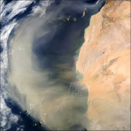
Every year, storms over West Africa disturb millions of tons of dust, and strong winds carry those particles westward into the skies over the Atlantic Ocean, where many hurricanes form. [Infographic: Storm Season! How, When & Where Hurricanes Form]
During a dust spike triggered by heavy rainfall, there's a drop in hurricanes in the Atlantic basin, Wang said. As the dust spreads into the atmosphere, it increases what's called the vertical wind shear, the change in wind direction that comes with height, Wang said. That's bad news for hurricanes, because too much wind shear can break up tropical cyclones (the general term for hurricanes and tropical storms).
A few years ago, scientists at the University of Wisconsin, Madison, pored over satellite data from the past 25 years and found that during years when the dust storms rose up, fewer hurricanes swept across the Atlantic. Periods of low duststorm activity were followed by more-intense hurricane activity.
Another curveball is warm water. Earlier this year, Wang and colleagues also published a report finding that, counterintuitively, a large pool of warm ocean water in the Atlantic Ocean keeps hurricanes away from the United States.
Wang said a hurricane behaves like a leaf floating in a river, totally at the whim of the current. So goes the river, so goes the leaf. A large Atlantic warm pool causes the atmospheric "river" to steer toward the northeast, carrying a hurricane with it and away from the United States.
This scenario played out during the 2010 hurricane season, when a large warm pool kept an otherwise active hurricane season from having an impact on the United States.
This story was provided by OurAmazingPlanet, a sister site to Live Science. You can follow OurAmazingPlanet staff writer Brett Israel on Twitter: @btisrael. Follow OurAmazingPlanet for the latest in Earth science and exploration news on Twitter @OAPlanet and on Facebook.

 Live Science Plus