
 Live Science Plus


Hurricane Rina's Strengthening Explained
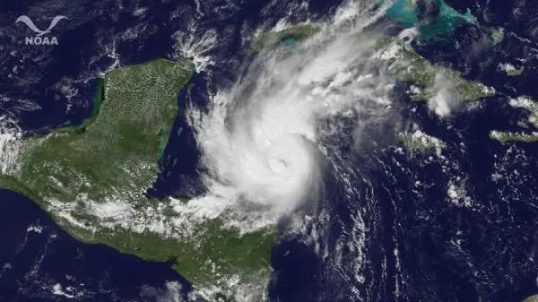
Hurricane Rina is not wasting any time in the tropics.
One day after becoming a hurricane, Rina is now a Category 2 storm and could hit major storm status (Category 3 and higher) by tonight (Oct. 25).
"Certainly not unusual, particularly in that part of the ocean," said Dennis Feltgen of the National Hurricane Center, referring to the northwest Caribbean Sea.

Toward the end of the Atlantic hurricane season — which begins each year on June 1 and ends Nov. 30 — storms shift west, more often forming in the Caribbean than off the west coast of Africa. The Caribbean's warm waters can feed a fast-growing storm.
The northwest Caribbean has the thickest layer of hot water in the Atlantic basin during hurricane season, said George Halliwell, an ocean modeler with the National Oceanic and Atmospheric Administration.
"This warm layer cools slowly during the fall, which is why late majorhurricanes ? Wilma and Mitch from a few years back ? can form in that region," Halliwell said.
Wind shear can disrupt a tropical storm or a hurricane, but Rina is not facing any.
Get the world’s most fascinating discoveries delivered straight to your inbox.
"You put those two factors together and you have the potential for pretty good strengthening," Feltgen told OurAmazingPlanet.
The storm, with winds of up to 100 mph (161 kph), is currently about 300 miles (480 kilometers) southeast of the towns of Tulum and Chetumal on Mexico's Yucatán Peninsula as it heads toward them and the rest of Yucatán's east coast. A hurricane watch is in effect, and the center of the storm could reach the coast by Thursday (Oct. 27).
Rina is the sixth hurricane and the 17th named storm of the 2011 Atlantic hurricane season. (Storms receive names once they reach tropical storm status.)
The 2011 season was predicted to be a doozy, with 14 to 19 named storms, including seven to 10 hurricanes and three to five major hurricanes (Category 3 or higher). The most recent storm before Rina was Phillipe, which formed in September and churned across the Atlantic for two weeks before becoming a hurricane Oct. 6. It weakened shortly thereafter, and the Atlantic, Gulf of Mexico and Caribbean were relatively quiet for most of October. (The letter Q is skipped in the alphabetical hurricane name list.)
This story was provided by OurAmazingPlanet, a sister site to Live Science. You can follow OurAmazingPlanet staff writer Brett Israel on Twitter: @btisrael. Follow OurAmazingPlanet for the latest in Earth science and exploration news on Twitter @OAPlanet and on Facebook.