 Live Science Plus


You are now subscribed
Your newsletter sign-up was successful
Want to add more newsletters?

Delivered Daily
Daily Newsletter
Sign up for the latest discoveries, groundbreaking research and fascinating breakthroughs that impact you and the wider world direct to your inbox.

Once a week
Life's Little Mysteries
Feed your curiosity with an exclusive mystery every week, solved with science and delivered direct to your inbox before it's seen anywhere else.

Once a week
How It Works
Sign up to our free science & technology newsletter for your weekly fix of fascinating articles, quick quizzes, amazing images, and more

Delivered daily
Space.com Newsletter
Breaking space news, the latest updates on rocket launches, skywatching events and more!

Once a month
Watch This Space
Sign up to our monthly entertainment newsletter to keep up with all our coverage of the latest sci-fi and space movies, tv shows, games and books.

Once a week
Night Sky This Week
Discover this week's must-see night sky events, moon phases, and stunning astrophotos. Sign up for our skywatching newsletter and explore the universe with us!
Join the club
Get full access to premium articles, exclusive features and a growing list of member rewards.
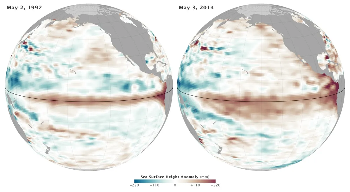
Time to place your bets: The chance of an El Niño developing this year continues to rise, forecasters with the National Atmospheric and Oceanic Administration said today (June 5).
NOAA's Climate Prediction Center (CPC) puts the odds of an El Niño at 70 percent this month and 80 percent during the fall and winter. But it's too soon to officially declare an El Niño, because the ocean and atmosphere are sending mixed signals, the CPC said in its monthly El Niño outlook, released today.
First, a quick definition: An El Niño is part of a natural climate cycle called the El Niño Southern Oscillation. The cycle swings between warmer water (an El Niño) to colder water (La Niña) in the eastern Pacific Ocean. [How El Niño Causes Wild Weather All Over the Globe (Infographic)]
During a potential El Niño year, scientists watch for unusually warm water in the eastern Pacific, along with weakening easterly trade winds, which usually block warm water from flowing toward the eastern Pacific.
Currently, wind and rainfall patterns don't quite match with a maturing El Niño. As warmer water moves eastward, so do the clouds and thunderstorms associated with it. Tropical rainfall patterns still haven't shifted away from Indonesia as expected during an El Niño year, the CPC said. Trade winds haven't slowed down yet, either, though the winds usually don't weaken until fall during an El Niño.
However, even though the atmosphere isn't showing strong signs of an El Niño, ocean temperatures have crossed the threshold that forecasters typically use to define an El Niño, the CPC said. Its latest measurements peg temperature anomalies between 1.1 and 2.9 degrees Fahrenheit (0.6 and 1.6 degrees Celsius), above the 0.9 F (0.5 C) threshold.
The missing atmospheric response to this warm water makes for a tricky forecast. The ocean is clearly heading toward an El Niño, but the atmosphere says "conditions neutral," the CPC said.
The CPC said significant uncertainty accompanies their outlook for strength: forecasters aren't sure whether this year's El Niño will be weak or strong. For now, models call for a moderate-size event.
But forecasters remain "just as confident that El Niño is likely to emerge," the CPC said.
El Niño is known for moving atmospheric moisture around the globe, causing snowy winters in the Northeast and wet winters in the Southwest. In turn, drought often strikes in Southeast Asia and Australia.
The next El Niño update will be released on July 10.
Email Becky Oskin or follow her @beckyoskin. Follow us @livescience, Facebook & Google+. Original article on Live Science.

