 Live Science Plus


You are now subscribed
Your newsletter sign-up was successful
Want to add more newsletters?

Delivered Daily
Daily Newsletter
Sign up for the latest discoveries, groundbreaking research and fascinating breakthroughs that impact you and the wider world direct to your inbox.

Once a week
Life's Little Mysteries
Feed your curiosity with an exclusive mystery every week, solved with science and delivered direct to your inbox before it's seen anywhere else.

Once a week
How It Works
Sign up to our free science & technology newsletter for your weekly fix of fascinating articles, quick quizzes, amazing images, and more

Delivered daily
Space.com Newsletter
Breaking space news, the latest updates on rocket launches, skywatching events and more!

Once a month
Watch This Space
Sign up to our monthly entertainment newsletter to keep up with all our coverage of the latest sci-fi and space movies, tv shows, games and books.

Once a week
Night Sky This Week
Discover this week's must-see night sky events, moon phases, and stunning astrophotos. Sign up for our skywatching newsletter and explore the universe with us!
Join the club
Get full access to premium articles, exclusive features and a growing list of member rewards.
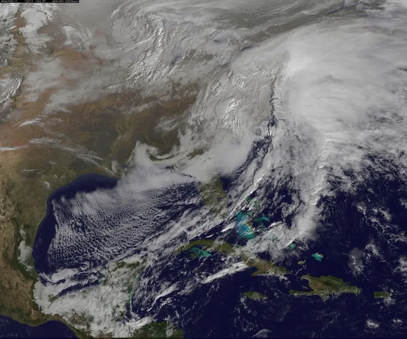
A treacherous winter storm that is sweeping across the southeastern United States has dumped snow, sleet and freezing rain over a region stretching from the Texas Gulf Coast to the Carolinas. As the storm moves into the Northeast, the icy blast is leaving a trail of destruction, with downed trees and power lines leaving hundreds of thousands of people without power in parts of Georgia and South Carolina.
As of this morning (Feb. 13), the National Weather Service (NWS) reported about an inch of ice accumulation from central Georgia into South Carolina. The harsh conditions are wreaking havoc on infrastructure, with nearly 230,000 homes and businesses in Georgia currently without power, according to Reuters.
Meteorologists say the worst is now over for the South, but lingering ice, particularly on tree branches and power lines, could exacerbate recovery efforts, said NWS spokesman Chris Vaccaro. [Massive Winter Storm 'Pax' Seen From Space | Time-Lapse Video]
"Precipitation that is able to accumulate on surfaces and objects, such as trees, power lines and flat roofs, adds tremendous weight and that's where the problems begin," Vaccaro told Live Science in an email.
This is because the type of precipitation that accumulated over the South was a mix of snow, sleet and freezing rain.
"'Wet' snow, which is snow that falls amid air temperatures around or above freezing, has a higher water content and can stick to trees, causing them to bend and break under the added weight," Vaccaro explained. "A large amount of wet snow that accumulates on a flat surface, such as a roof, can cause a structural failure. This is unlike light, powdery snow that has a lower water content and primarily accumulates on the ground instead of sticking to and stacking up on more fragile surfaces."
Freezing rain, which is precipitation that falls as rain but freezes on contact, can also build up on trees and power lines, but is particularly troublesome because it makes roads extremely dangerous, said Bernie Rayno, senior meteorologist for AccuWeather, which provides content to Live Science.
"The real problem in the South yesterday was many places had freezing rain, and when you look at winter precipitation, none of them are great for travel, but freezing rain is the worst," Rayno told Live Science.
Temperatures in the Southeast are expected to warm up this afternoon, which should help melt some of the ice, but forecasts indicate that conditions could fall below freezing again tonight, Rayno said.
"The big thing for getting rid of the ice will be to melt it during the day with temperatures above freezing," he said.
In the meantime, the winter storm has moved into the Northeast, and is walloping cities along the East Coast with snow, sleet and rain. In coastal areas, the snow is expected to turn into rain over the course of the day, but sleet and freezing rain is possible during the transition, according to the NWS.
Follow Denise Chow on Twitter @denisechow. Follow Live Science @livescience, Facebook & Google+. Original article on Live Science.

