 Live Science Plus


You are now subscribed
Your newsletter sign-up was successful
Want to add more newsletters?

Delivered Daily
Daily Newsletter
Sign up for the latest discoveries, groundbreaking research and fascinating breakthroughs that impact you and the wider world direct to your inbox.

Once a week
Life's Little Mysteries
Feed your curiosity with an exclusive mystery every week, solved with science and delivered direct to your inbox before it's seen anywhere else.

Once a week
How It Works
Sign up to our free science & technology newsletter for your weekly fix of fascinating articles, quick quizzes, amazing images, and more

Delivered daily
Space.com Newsletter
Breaking space news, the latest updates on rocket launches, skywatching events and more!

Once a month
Watch This Space
Sign up to our monthly entertainment newsletter to keep up with all our coverage of the latest sci-fi and space movies, tv shows, games and books.

Once a week
Night Sky This Week
Discover this week's must-see night sky events, moon phases, and stunning astrophotos. Sign up for our skywatching newsletter and explore the universe with us!
Join the club
Get full access to premium articles, exclusive features and a growing list of member rewards.
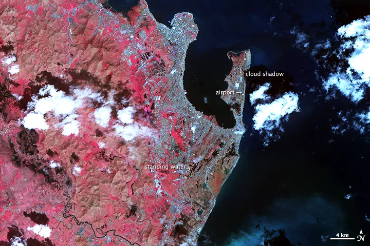
From hills laid bare by winds to coastlines swamped by floodwaters, the massive swath of destruction across the Philippines city of Tacloban from Super Typhoon Haiyan is visible even from space.
One of the most powerful storms to ever hit the Philippines, Super Typhoon Haiyan arrived on Nov. 8 with sustained winds of up 190 mph (305 km/h) in the hours before it made landfall. The aftermath of the storm can be seen in before and after false-color images captured by the ASTER sensor aboard NASA's Terra satellite.
The most dramatic change is in the hills above Tacloban, reports NASA's Earth Observatory. Comparing ASTER images snapped in 2004 and in 2013, just days after the storm, reveals the hills were stripped bare of vegetation. (Plant-covered land is red; bare ground is tan.)

Along the coast, where a powerful storm surge flooded Tacloban, the ASTER image suggests mud and floodwaters still cover the ground. About 800,000 people were moved to storm shelters, but Haiyan's deadly flooding reached a height of 20 feet (6 meters) in the central Philippines. Further inland, the blurry outline of the city's neatly gridded streets could indicate debris blown down by the storm, the Earth Observatory said.
NASA scientists are using satellite imagery to produce damage maps that will help aid disaster relief efforts in the Philippines, NASA officials said in a Nov. 14 release.
Current estimates place the death toll at more than 2,000 people. Thousands remain missing and relief efforts have been hampered by the difficulty of reaching remote islands, according to news reports.
Email Becky Oskin or follow her @beckyoskin. Follow us @OAPlanet, Facebook & Google+. Original article on LiveScience's OurAmazingPlanet.

