Our amazing planet.

Happy Mardi Gras: New Orleans from Above

New Orleans in an astronaut photograph
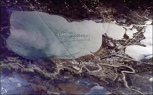
New Orleans and the various bodies of water that surround it were snapped in this astronaut photograph from 2006. (Image credit: NASA)

The storied city of New Orleans within a shallow depression underlain by unconsolidated (loosely settled) river sediments, which puts its average elevation at about 6 feet (1.8 meters) below sea level.

In this astronaut photograph from November 2006, sunglint — light reflected directly back to the camera onboard the International Space Station (ISS) from a water surface — accentuates the wetland setting of New Orleans by highlighting the numerous lakes, ponds, and rivers (in various shades of silver-gray) surrounding the city.

A complicated system of levees, pumps, and upstream control structures along the Mississippi River keep the waters of the river and Lake Pontchartrain to the north at bay. Of course, these systems aren't fool-proof, and floods along the river and other events can cause the city to flood, as was most recently seen in the devastating floods after Hurricane Katrina in 2005.

These systems are also partly responsible for the fact that New Orleans is sinking: Groundwater withdrawal, reduction of sediment delivery by the Mississippi River (spanning the lower part of the image) because of flood control and other engineering, and land use changes, such as draining of wetlands for development, all contribute to ground subsidence, according to a NASA statement.

Live Science Staff
For the science geek in everyone, Live Science offers a fascinating window into the natural and technological world, delivering comprehensive and compelling news and analysis on everything from dinosaur discoveries, archaeological finds and amazing animals to health, innovation and wearable technology. We aim to empower and inspire our readers with the tools needed to understand the world and appreciate its everyday awe.