

Images: Antarctic Odyssey - The Majestic Transantarctic Mountains

Central Churchill Mountains

Over the course of 40 years of research and 13 seasons of field work in the Transantarctic Mountains, geologist Edmund Stump took literally thousands of photos of dazzling Antarctic landscapes. The next logical step was to write a book about the majestic mountains he'd spent decades exploring. In this gallery, you can see images from his book, "The Roof at the Bottom of the World: Discovering the Transantarctic Mountains" (Yale University Press, 2011). Stump himself wrote the descriptions of the icy landscapes. Click through for an eyeful, along with a fascinating history lesson in Antarctic exploration.
The Central Churchill Mountains
The central Churchill Mountains, viewed in this scene from Mt. Durnford, were first seen by Scott's Southern Party (Robert Falcon Scott, Ernest Shackleton, and Edward Wilson) in mid December of 1902, as they pushed into the unknown. This area is about 100 miles north of their farthest-south point at the mouth of Nimrod Glacier.
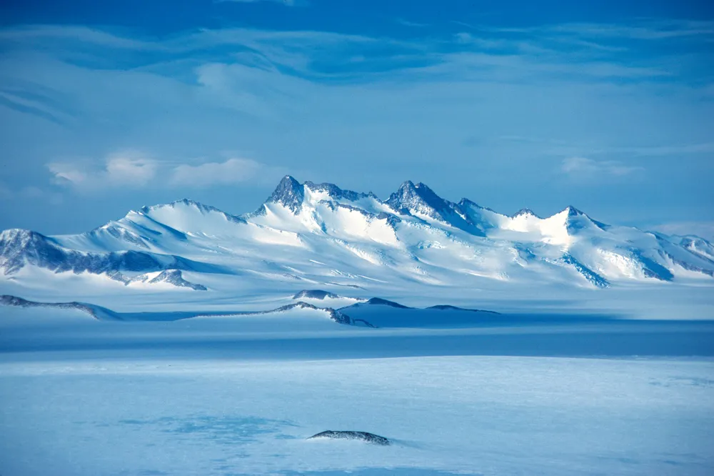
The Admiralty Mountains

This aerial image of a portion of the Admiralty Mountains is viewed to the east in the opposite direction from the sightings by Ross (January, 1840) and later explorers. Mt Minto, the highest point in northern Victoria Land, is the dark, faceted peak in the upper right of the image. Mt Adam is the prominent peak a short distance to the left at the culmination of three ridgelines. The dark massif with the rounded summit directly in front of Mt. Adam is Mt. Royalist. The dramatic peak half way long the ridgeline to the left is Mt. Black Prince. Mt. Royalist and Mt. Black Prince were first sighted in 1958 by the New Zealand geological party working on Tucker Glacier, the first persons to explore the interior of northern Victoria Land. The Adare Peninsula is the dark cliff that subtly rises and falls on the far side of Robertson Bay in the rear of the image. Ridley Beach, the site of Broschgrevink's winterover (1900), is at the northern (left) tip of the peninsula.
Amundsen Glacier

Connecting the East Antarctic Ice Sheet with the Ross Ice Shelf, Amundsen Glacier snakes into view from behind Breyer Mesa, sweeps under Nilsen Plateau, then caroms through staggered ridgelines to the ice shelf in the fore. There the Geological Party of Byrd's First Antarctic Expedition (1928-30) was passing on the afternoon of 17 December 1929.
Adélie Penguins at Cape Royds

Adélie penguins couple on the rookery at Cape Royds about 100 yards from the doorstep of the winter-quarters hut used by Ernest Shackleton's 1907-09 Nimrod Expedition. A group of Emperor penguins huddles next to the ice front in the middle ground, while several Weddell seals lie on the ice to the right. The volcanic cone of Mt. Discovery rises in the center distance to the southwest across McMurdo Sound.
Mout Gould
Mt Gould rises to the south of Leverett Glacier. Discovered by the Geological Party of Byrd's First Antarctic Expedition (1928-30) from the summit of Supporting Party Mountain, the end point of their traverse. This twin-peaked citadel is yet to be trod upon by explorers' feet.
Minna Bluff

On November 4, 1911, Scott's party was camped new the end of Minna Bluff, the hooked landmark and depot point for all parties headed south from Ross Island. The bluff extends 35 miles away from the viewer toward the conical Mt. Discovery. Beyond that the Royal Society Range marks the horizon. Note the gashes in the ice caused by the motion of the Ross Ice Shelf from left to right around Minna Bluff.
Mount Erebus

When James Clark Ross discovered Mount Erebus, the southernmost active volcano on Earth, he described it as emitting smoke and flame in great profusion. This massive shield volcano, rising 12,450 feet out of the sea, was first scaled in March, 1908 by members of Ernest Shackleton's Nimrod Expedition.
Billowy Clouds Over Grizzly Peak

Intermittent stratus clouds billow over the summit of Grizzly Peak in the foreground and over the foothills of the Hays Mountains on the far side of Scott Glacier, flowing from left to right in the left foreground. In the distance, the shadowed face of the Faulkner Escarpment demarcates the eastern margin of the Nilsen Plateau. The Geological Party of Byrd's Second Antarctic Expedition passed this area in December 1934 during their traverse of discovery to the head of Scott Glacier.
CTAN Camp Outpost

CTAM (Central Transantarctic Mountains) Camp during the 2010-11 field season. This outpost on Bowden Neve served 100 scientists with air logistics for research in the surrounding area.
Churchill Mountains Conglomerate

Geologists examine an outcrop of conglomerate in the Churchill Mountains.

