
 Live Science Plus


Tornado Damage from Above

Alabama Tornado Outbreak

A massive outbreak of tornadoes roared across the Deep South on April 27. The storm spawned nearly 250 tornadoes and killed nearly 350 people. Alabama was hit the hardest. Twisters carved across the state, claiming more than 200 lives.
The National Weather Service has deployed storm survey teams to figure out how strong the tornadoes were and how far they traveled. Already, two EF-5 tornadoes, the strongest on the tornado damage scale, have been confirmed. The EF-5 twisters are the first in the United States in three years .
In this image gallery, we take a look at the amazing images that have already been gathered, including storm tracks, satellite images and aerial damage photos.

Souther Supercell

This radar sequence shows the path of the tornado supercell thunderstorms that tracked from western Mississippi into southwest North Carolina. The outbreak is now thought to surpass the 1974 "Super Outbreak" to become the second deadliest outbreak of tornadoes in recorded history.
Southern Tornado Tracks

In the above image, bright red, orange and yellow lines show the tracks where rotation in the storms was strongest on Doppler radar. Yellow lines depict the most intense rotations. Many of the tornadoes were EF-4 strength on the Enhanced Fujita Damage scale, with winds nearing 200 mph (322 kph). [The Tornado Damage Scale in Images ]
Tornado Tracks Alabama
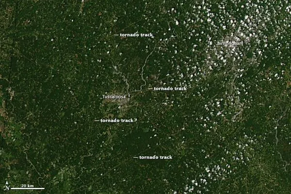
The hardest-hit community during the outbreak was Tuscaloosa, Ala. The above image, acquired by the Moderate Resolution Imaging Spectroradiometer (MODIS) on NASA's Aqua satellite on April 28 shows three tornado tracks through and around the city.
Southern Storms Satellite Image

A NASA satellite captured this image of the explosive storm clouds as they moved across the Deep South on April 27.
Get the world’s most fascinating discoveries delivered straight to your inbox.
Tornado Track Georgia
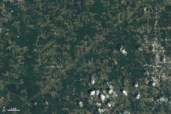
A pale green swath in this Landsat image from April 28 reveals the path of a tornado outside of Griffin, Georgia.
The tornado was on the ground between 12:03 and 12:28 a.m. local time on April 28, hours before the image was taken. By the time the funnel cloud lifted, the tornado had covered about 20 miles (30 km) with a path about half a mile wide, said the National Weather Service.
The tornado was an EF-3 tornado with winds of about 140 mph (225 kph).
Tuscaloosabefore

Storm survey teams conducted aerial surveys above Tuscaloosa. The following images show before and after photos of the devastation.
Tuscaloosaafter

The same area as in the previous photo after the tornado went through.
Tuscaloosabefore

With few basements in Dixie Alley , not many places were safe in the paths of the tornadoes. Many entire neighborhoods were completely obliterated.
Tuscaloosaafter

Trees and houses have clearly been demolished in the bottom area of this image.
Tuscaloosabefore

As these images show, even solidly build structures where leveled. The tornado that ripped through Tuscaloosa has been rated a high-end EF-4, with winds of up to 190 mph (306 kph).
