


Kilauea Volcano: Facts About the 30-Year Eruption
Kilauea is one of the world’s most active volcanoes. It is a shield-type volcano that makes up the southeastern side of the Big Island of Hawaii. The volcano rises 4,190 feet (1,227 meters) above sea level and is about 14 percent of the land area of the Big Island. The summit caldera contains a lava lake known as Halema`uma`u that is said to be the home of the Hawaiian volcano goddess, Pele.
To the casual observer, Kilauea appears to be part of the larger volcano Mauna Loa, but geological data indicates that it is a separate volcano with its own vent and conduit system. Kilauea has had more than 60 recorded eruptions in the current cycle, according to the U.S. Geological Survey, and has been erupting on a continuous basis since 1983.
On May 3, 2018, the volcano erupted dramatically, several hours after a magnitude-5.0 quake struck the Big Island. The eruption spewed lava into residential subdivisions in the Puna district of the Big Island, prompting mandatory evacuations of the Leilani Estates and Lanipuna Gardens subdivisions, the Honolulu Star-Advertiser reported.

Formation theories
Scientists have two theories about the formation of the Hawaiian Islands. Unlike most volcanoes, the Hawaiian chain sits squarely in the middle of the Pacific plate rather than on a tectonic boundary. In 1963, J. Tuzo Wilson proposed the “hotspot theory” to explain this unusual placement. Wilson proposed that the linear geography of the Hawaiian Islands is due to the movement of the Pacific plate over a stationary point of great heat from deep within the Earth..

Heat from this localized hotspot melts the Pacific plate above the hotspot as the rocky crust is pushed over it by the spreading seafloor along the plate boundary. The melting rock of the Pacific plate produces magma. Less dense than the solid rock of the plate, the magma rises through the mantle and the crust as a thin thermal plume, erupting beneath the ocean to form an active seamount. Over time, the countless eruptions increase the height of the seamount until it breaks the ocean surface and becomes an island volcano.
As the Pacific plate continues to move northward over time, the island is pushed away from the hotspot and a new island begins to form over the hotspot. In 2009, Cecily Wolfe of the University of Hawaii used sea bottom sensors to identify how seismic waves propagate through the pliable mantle layer beneath the Earth’s crust. She believes her evidence has pinpointed the location of the hotspot.
In contrast, a new study done by geologists from MIT and Purdue University in 2011, mapped rock layers within the crust. They could find no evidence of a single thermal plume. Instead, they found a “pancake shaped” layer of abnormally hot rock in the crust only about 403 miles beneath the surface, well above the mantle. Temperatures were 300 to 400 degrees C (572 to 752 F) hotter than expected at that depth. This data suggests that hotspots may not be as deep as previously thought and may not be permanently fixed in one spot. Wolfe acknowledges the importance of the new find, but believes it will take much more work to truly explain how her thermal plume and the “pancake” of hot rocks are related and how they provide the heat source for Kilauea and the other active volcanoes of the Hawaiian Islands. “Neither theory is rock solid. Nothing in earth science is perfect,” Wolfe observed.
Get the world’s most fascinating discoveries delivered straight to your inbox.
Eruption history
Native Hawaiian oral traditions record the extraordinary eruptive history of Kilauea long before European and American missionaries wrote about it in their journals. Scientific study of the volcano began when geologist Thomas Jagger of the Massachusetts Institute of Technology visited Hawaii on a lecture tour and was approached by local businessmen. The Hawaiian Volcano Research Association (HVRA) was formed in 1909. In 1919, Jagger convinced the National Weather Service to take over the pioneering research, and in 1924 the observatory was taken over by the U.S. Geological Survey.
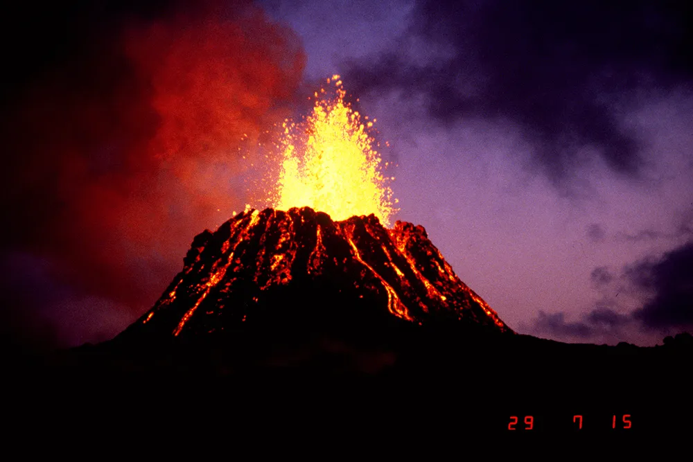
The current ongoing eruption cycle began on Jan. 3, 1983, along the middle of the east rift zone. By April, the eruptions became localized at one vent. Lava fountains built a cinder and spatter cone 836 feet high (255 meters) that was named Pu`u `Ō`ō. The frequent short eruptions produced thick chunky lava flows that usually cooled and halted before reaching the coast. However, in July 1983, the lava made its inexorable advance into the nearby Royal Gardens subdivision and destroyed 16 homes. The expensive subdivision was largely abandoned.
In 1986, lava flows cut through the town of Kalapana as the lava made its way to the sea. As the lava field spread, cooled and spread again over the next three years it destroyed many homes and the Visitor Center in Hawai`i Volcanoes National Park. In March 1990, Kilauea entered its most destructive eruption period in modern history. Over the summer more than 100 homes, a church and a store were buried beneath 50 to 80 feet (15 to 24 meters) of lava. [Explosive Images: Hawaii's Kilauea Erupts for 30 Years]
On March 3, 2012, the very last house in the Royal Gardens subdivision was abandoned by 61-year-old Jack Thompson. For years, Thompson had watched as lava claimed the homes of his neighbors, leaving the area to Thompson and a few hardy squatters. The last roads leading to Royal Gardens were closed in 2008, forcing Thompson to hike several miles to reach an access road whenever he needed something from town, but he still refused to leave. Finally on the morning of March 3, Thompson and a friend were evacuated by helicopter as lava finally consumed his home.
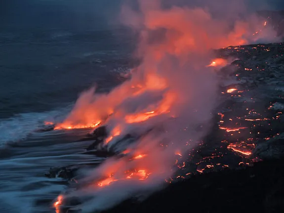
Lava in Halema`uma`u crater overflowed the crater's ledge in October 2012 [Video: Lava in Hawaiian Volcano Reaches Highest Recorded Level], and lava reached the ocean in November [Video: Hawaii's Kilauea Volcano Spills Lava into the Sea] when it flooded the ledge of the crater. Lava flowed over the ledge again in January 2013 and continues to flow into the ocean, according to USGS.
The volcano has destroyed hundreds of homes and other structures and frequently damages local utilities and roads. Activity at the summit and along the rift zones can be observed online through webcams placed within the caldera, and information on Kilauea’s activity is updated daily on the USGS website.
Staff writer Becky Oskin contributed to this article.
Additional resources
- Hawaiian Volcano Observatory: Kilauea
- U.S. Geological Survey: 'Hotspots': Mantle Thermal Plumes
- USGS: Volcano Watch