 Live Science Plus


You are now subscribed
Your newsletter sign-up was successful
Want to add more newsletters?

Delivered Daily
Daily Newsletter
Sign up for the latest discoveries, groundbreaking research and fascinating breakthroughs that impact you and the wider world direct to your inbox.

Once a week
Life's Little Mysteries
Feed your curiosity with an exclusive mystery every week, solved with science and delivered direct to your inbox before it's seen anywhere else.

Once a week
How It Works
Sign up to our free science & technology newsletter for your weekly fix of fascinating articles, quick quizzes, amazing images, and more

Delivered daily
Space.com Newsletter
Breaking space news, the latest updates on rocket launches, skywatching events and more!

Once a month
Watch This Space
Sign up to our monthly entertainment newsletter to keep up with all our coverage of the latest sci-fi and space movies, tv shows, games and books.

Once a week
Night Sky This Week
Discover this week's must-see night sky events, moon phases, and stunning astrophotos. Sign up for our skywatching newsletter and explore the universe with us!
Join the club
Get full access to premium articles, exclusive features and a growing list of member rewards.
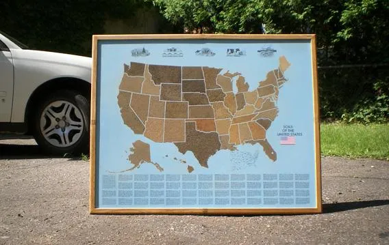
Quick: What's your official state soil? If you're like most Americans, you probably have no idea what you've been standing on all these years — or that you even had an official state soil.
Well, wonder no more. Retired art director Les Gregor discovered a novel way to use his creative energies when he dropped a piece of tape on the ground. When he picked it up, according to Slate.com, it had a perfect, uniform coating of soil on its sticky side.
Gregor, 85, then decided to design a map of the United States with each state covered in a thin film of that state's official soil; state agriculture departments assisted by sending a sample of their finest soil to Gregor. On his map, Nebraska, for example, is covered with the state's dark brown Holdrege loam, while Maine is represented by its pale Chesuncook glacial soil.
Gregor sells his maps ($195 including framing) from his home in Montreal. Asked why he chose to develop maps of the United States and not his native Canada, he told Slate.com, "We only have 11 provinces and not as much soil variation. It would be boring."
Follow LiveScience on Twitter @livescience. We're also on Facebook & Google+.

