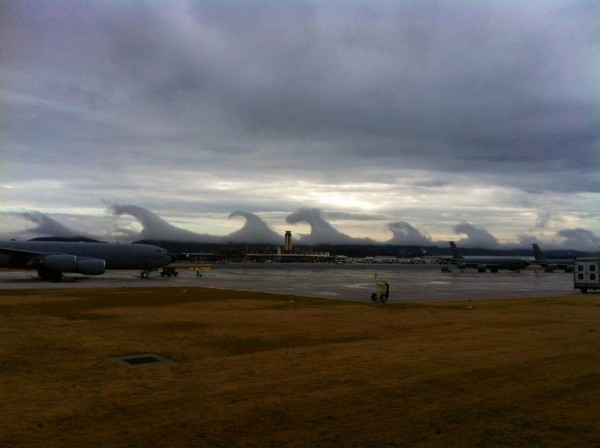
Giant Tsunami-Shape Clouds Roll Across Alabama Sky

Get the world’s most fascinating discoveries delivered straight to your inbox.
You are now subscribed
Your newsletter sign-up was successful
Want to add more newsletters?

Delivered Daily
Daily Newsletter
Sign up for the latest discoveries, groundbreaking research and fascinating breakthroughs that impact you and the wider world direct to your inbox.

Once a week
Life's Little Mysteries
Feed your curiosity with an exclusive mystery every week, solved with science and delivered direct to your inbox before it's seen anywhere else.

Once a week
How It Works
Sign up to our free science & technology newsletter for your weekly fix of fascinating articles, quick quizzes, amazing images, and more

Delivered daily
Space.com Newsletter
Breaking space news, the latest updates on rocket launches, skywatching events and more!

Once a month
Watch This Space
Sign up to our monthly entertainment newsletter to keep up with all our coverage of the latest sci-fi and space movies, tv shows, games and books.

Once a week
Night Sky This Week
Discover this week's must-see night sky events, moon phases, and stunning astrophotos. Sign up for our skywatching newsletter and explore the universe with us!
Join the club
Get full access to premium articles, exclusive features and a growing list of member rewards.
For a morning, the sky looked like a surfer's dream: A series of huge breaking waves lined the horizon in Birmingham, Ala., on Friday (Dec. 16), their crests surging forward in slow motion. Amazed Alabamans took photos of the clouds and sent them to their local weather station, wondering, "What are these tsunamis in the sky?"
Experts say the clouds were pristine examples of "Kelvin-Helmholtz waves." Whether seen in the sky or in the ocean, this type of turbulence always forms when a fast-moving layer of fluid slides on top of a slower, thicker layer, dragging its surface.
Water waves, for example, form when the layer of fluid above them (i.e., the air) is moving faster than the layer of fluid below (i.e., the water). When the difference between the wind and water speed increases to a certain point, the waves "break" — their crests lurch forward — and they take on the telltale Kelvin-Helmholtz shape. [Astonishing Video Shows a Face in the Clouds]
According to Chris Walcek, a meteorologist at the Atmospheric Sciences Research Center at the State University of New York, Albany, fast-moving air high in the sky can drag the top of slow-moving, thick clouds underneath it in much the same way.
"In the pictures [of the Birmingham sky] there is probably a cold layer of air near the ground where the wind speed is probably low. That is why there is a cloud or fog in that layer," Walcek told Life's Little Mysteries, a sister site to LiveScience. "Over this cloudy, cold, slow-moving layer is probably a warmer and faster-moving layer of air."
Most of the time, the difference in wind speed and temperature between two layers of the atmosphere is small, and so the fast-moving air on top "simply slides smoothly over the slower-moving air like a hockey puck sliding along an ice surface," Walcek said. At the other extreme, if the wind-speed difference is too large, the interface between the two layers breaks down into random turbulence.
Kelvin-Helmholtz waves form when the difference in the temperature and wind speed of the two layers hits a sweet spot. "What [these pictures] show is air between these two atmospheric layers that is just very close to that threshold for turbulence, and mixing to mix the two layers together," he said.
Get the world’s most fascinating discoveries delivered straight to your inbox.
This story was provided by Life's Little Mysteries, a sister site to LiveScience. Follow Natalie Wolchover on Twitter @nattyover. Follow Life's Little Mysteries on Twitter @llmysteries, then join us on Facebook.
Natalie Wolchover was a staff writer for Live Science from 2010 to 2012 and is currently a senior physics writer and editor for Quanta Magazine. She holds a bachelor's degree in physics from Tufts University and has studied physics at the University of California, Berkeley. Along with the staff of Quanta, Wolchover won the 2022 Pulitzer Prize for explanatory writing for her work on the building of the James Webb Space Telescope. Her work has also appeared in the The Best American Science and Nature Writing and The Best Writing on Mathematics, Nature, The New Yorker and Popular Science. She was the 2016 winner of the Evert Clark/Seth Payne Award, an annual prize for young science journalists, as well as the winner of the 2017 Science Communication Award for the American Institute of Physics.
 Live Science Plus


