It's quick and easy to access Live Science Plus, simply enter your email below. We'll send you a confirmation and sign you up for our daily newsletter, keeping you up to date with the latest science news.
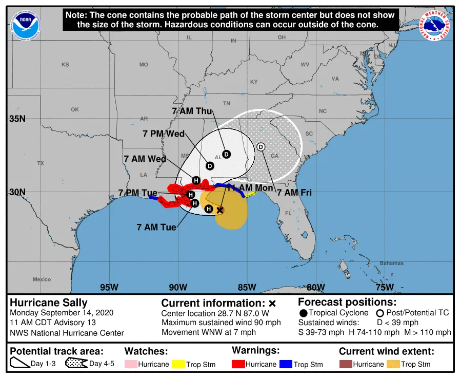
A map shows the range of possible paths for the center of Hurricane Sally, though the National Hurricane center said it's still uncertain what direction the storm will go.
Hurricane Sally is strengthening in the Gulf of Mexico and is expected make landfall somewhere on the central Gulf Coast later today (Sept. 14).
The slow-moving storm has been drifting northwest off the coast toward Louisiana, and was officially upgraded from tropical storm to hurricane this afternoon. The National Hurricane Center (NHC) said it's still too soon to tell where exactly its center will move onshore. It's packing an "extremely dangerous and life-threatening storm surge" that threatens people living on the Louisiana, Mississippi and Alabama coastlines, the NHC said. And with forecasts suggesting that it will remain partly over the Gulf's warm, storm-feeding water as it moves ashore, the NHC said Sally could remain a dangerous hurricane for a long time after landfall.
Dangerous flash floods are also likely, according to the NHC, as well as major flooding along rivers and in urban areas.
The Gulf Coast has already taken a beating this hurricane season, with the one-two punch of tropical storm Marco and the monster hurricane Laura hitting western Louisiana in the same week in August. According to the Post and Courier, 134,000 people were still without power in Louisiana this past weekend, two weeks after Laura.
Twenty-three thousand are still living in Red Cross housing from that last pair of storms in Louisiana, the Post and Courier reported, though they've gotten less attention than the more than 100,000 people fleeing massive wildfires on the West Coast. Scientists believe that both the more intense hurricanes and hotter and larger wildfires occurring right now are consequences of climate change.
Sign up for the Live Science daily newsletter now
Get the world’s most fascinating discoveries delivered straight to your inbox.
While this storm is the only Atlantic cyclone posing an immediate threat to land, it's not the only storm in the Atlantic. The NHC is simultaneously tracking four other significant storms right now, including hurricane Paulette, which passed directly over Bermuda today (several hundred miles east of North Carolina). None besides Sally and Paulette pose immediate threats to land.
There are five named tropical storms in the Atlantic right now.
(Image credit: National Hurricane Center)
Sally, like most hurricanes this year, is also a record setter: Atlantic cyclones are named in alphabetical order as they reach tropical storm strength, and no "S" storm has ever come this early before. Sally was named on Sept. 12. That's 21 days earlier than the previous "S" record-holder: Stan in 2005.
With Tropical Storms Teddy and Vicky forming in the Atlantic this morning, 21 and 22 days earlier than record-holders, Azores (which reached Tropical Storm strength on Oct. 4, 2005, but was named out of order), and Tammy (Oct. 5, 2005). Teddy is already forecast to become a major hurricane and is expected to move north through the Atlantic without impacting the Carribean or North American mainland.
There's only one slot left on the NHC's list of Atlantic storm names: Wilfred. (The list skips the letters Q, X, Y and Z.)
Once the prepared names are exhausted, the NHC will move on to Greek letters for storms. In 2005, the previous busiest storm year, six Greek-letter storms formed, culminating in Zeta (the sixth of 24 possible Greek letters) on Dec. 30.
Most tropical storms form during August, September and October.
Rafi joined Live Science in 2017. He has a bachelor's degree in journalism from Northwestern University’s Medill School of journalism. You can find his past science reporting at Inverse, Business Insider and Popular Science, and his past photojournalism on the Flash90 wire service and in the pages of The Courier Post of southern New Jersey.