It's quick and easy to access Live Science Plus, simply enter your email below. We'll send you a confirmation and sign you up for our daily newsletter, keeping you up to date with the latest science news.
Hurricane Sally made landfall near Gulf Shores, Alabama, early Wednesday morning (Sept. 16) as a Category 2 hurricane after strengthening overnight. The slow-moving storm hit with sustained winds of 105 mph (169 km/h), toppling trees, cutting power and dropping extreme amounts of rain, according to CNN.
After landfall, the storm weakened into a Category 1 hurricane. It is now about 15 miles west/northwest of Pensacola, Florida and has maximum sustained winds of 80 mph (130 km/h), according to the National Hurricane Center (NHC).
"Historic and catastrophic flooding is unfolding," from Mobile Bay, Alabama to near Tallahassee, Florida, according to the NHC. This rainfall will likely lead to widespread river flooding, according to the NHC. This morning, Hurricane Sally was moving at an extremely slow pace, near 3 mph (6 km/h), prolonging exposure to rainfall and high winds. As of 11 a.m. EDT, the storm has sped up slightly to 5 mph (7 km/h).
Sally has already dropped up to 18 inches (46 centimeters) of rain, "creating catastrophic flash flooding," the National Weather Service Weather Prediction Center wrote on Twitter this morning. The storm may drop somewhere between 10 to 35 inches (25 to 89 cm) of rain across parts of Alabama and the Florida Panhandle, according to the NHC.
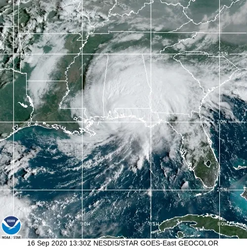
Hurricane Sally has made landfall and is continuing to move slowly in a north/northeastern direction.
(Image credit: NOAA/National Hurricane Center)
"Life-threatening" storm surges are occurring along portions of the coast from Alabama to the western Florida Panhandle, including Pensacola Bay in Florida according to the NHC. More than 430,000 people in the Florida Panhandle and southern Alabama have already lost power, according to poweroutage.us. At least 3 to 4 feet (0.9 to 1.2 meters) of water flooded downtown Pensacola, according to a photo retweeted by the National Weather Service in Mobile.
Water levels at the National Oceanic and Atmospheric Administration (NOAA) tide stations recorded "moderate flood levels," with more than 5.5 feet (1.6 m) above normal high tide this morning, NOAA's Ocean Service tweeted. High-water rescues were underway Wednesday morning, according to CNN.
Sign up for the Live Science daily newsletter now
Get the world’s most fascinating discoveries delivered straight to your inbox.
The storm is currently moving in a north/northeastern direction. It is expected to hasten its pace "slightly" later today and tonight and quicken even more on Thursday. The center of Sally will move across the western Florida panhandle and southeastern Alabama through early Thursday and move over central Georgia on Thursday and over South Carolina Thursday night, according to the NHC.
Yasemin is a staff writer at Live Science, covering health, neuroscience and biology. Her work has appeared in Scientific American, Science and the San Jose Mercury News. She has a bachelor's degree in biomedical engineering from the University of Connecticut and a graduate certificate in science communication from the University of California, Santa Cruz.