The equatorial waters of the Pacific Ocean have made the transition from the warming flow, known as El Niño, 10 months ago to its cooler cousin, La Niña, NASA scientists report.
The widespread cooling of the ocean surface, revealed by satellite data, is expected to intensify and could worsen dry spells and forest-fire-friendly conditions in the western United States, the scientists warn.
"This La Niña has strengthened for the past four months, is strong now and is still building," said climatologist Bill Patzert of NASA's Jet Propulsion Laboratory in Pasadena, Calif. "It will surely impact this coming winter's weather and climate."
Latest Videos From
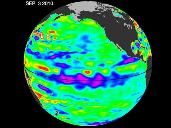
Researchers uncovered the change in sea surface temperatures by examining data from the U.S-French oceanography satellite, Ocean Surface Topography Mission/Jason-2, which looks at sea surface heights.
Because the height of the surface is an indicator of how much of the sun's heat is being stored in the upper ocean (warmer waters tend to expand, increasing sea surface heights), scientists were able to calculate the change in ocean temperature from satellite data collected over a 10-day period in early September.
La Niña ocean conditions often follow an El Niño episode, and the two systems are essentially two sides of the same coin — El Niño the warm side, La Niña the cool side.
During a La Niña episode, trade winds are stronger than normal, and the cold water found along the west coast of South America extends to the central equatorial Pacific.
La Niña episodes change global weather patterns. They are associated with less moisture in the air, resulting in less rain along the coasts of North and South America and the equator, and more rain in the far western Pacific. Lower rain amounts can have a significant impact on already water-starved areas.
"After more than a decade of mostly dry years on the Colorado River watershed and in the American Southwest, and only one normal rain year in the past five years in Southern California, water supplies are dangerously low," Patzert said.
Patzert said that this La Niña could deepen the drought in the already parched Southwest "and could also worsen conditions that have fueled Southern California's recent deadly wildfires."
NASA will continue to track this change in Pacific climate.
This article was provided by OurAmazingPlanet, a sister site to LiveScience.