


New Stamps Highlight Cool Clouds
See all the stamps below
The United States Postal Service (USPS) recently issued 15 new stamps with clouds as the theme, all in the interest of science education.
The stamps were created to promote National Stamp Collecting month in October, but beyond philatelic interests, officials figured they would be a good way to get people thinking about the science of weather.

The stamps were issued at the Blue Hill Meteorological Observatory south of Boston, where America's official weather recording began in 1885.
"When you hear someone say this is the coldest day on record," says Mark Saunders of the USPS, "well, the record started there."
Long ago, Blue Hill compiled "the first basic climatology of cloud types, height, and velocity in the Westerm Hemisphere," according to the observatory. Now the goal of Blue Hill is to continue to provide detailed climate records as well as educate the public about atmospheric science, hence their collaboration with the post office.
The science of clouds
Get the world’s most fascinating discoveries delivered straight to your inbox.
Clouds rely on factors that include changes in temperature, pressure, humidity, and prevalence of dust for their survival. Water is the key ingredient, however, and its constant movement through the phases of solid, liquid, and vapor determine when clouds form and how long they last.
The temperature surrounding water provides energy to the molecule. At its lowest energy water is a solid, at its highest a vapor. When temperatures increase around water at the Earth's surface some molecules become energetic enough to escape and rise into the atmosphere as vapor.
As water rises the air temperature eventually cools and the amount of energy in the water molecule decreases, changing the vapor into a liquid. If that liquid has something to cling to, usually dust, the water molecules are able to start to cling together and form clouds.
"I hope the stamps remind everyone of the science, knowledge and extraordinary beauty of the ever-changing canvas in the sky above us," said William Johnstone, a former Air Force weather observer and Secretary of the Board of Governors of the Postal Service.
There are ten categories of clouds and 27 subtypes divided by their height, shape, color and associated weather. The USPS sheet, however excluded the tenth type of cloud, called nimbo stratus because it is the large, dark sheet that hovers low to the ground right before a heavy down pour or snow storm. This type of cloud looks like a uniform gray sky, Saunders said.

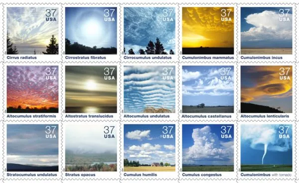
Cirrus radiatus Composed of windblown ice crystals, cirrus are fibrous, often wispy clouds that appear in isolated patches or cover large areas of the sky.Cirrus radiatus appear to emerge from the horizon in parallel bands.
Cirrostratus fibratus Relatively transparent cirrostratus fibratus clouds occur mostly in winter and often produce a halo effect around the sun or moon.Thickening cirrostratus frequently indicate the approach of a frontalsystem.
Cirrocumulus undulatus Cirrocumulus undulatus are patches or layers of small puffy clouds arranged in patterns. They have a rippled appearance due to wind shear and usually cover only a small portion of the sky.
Cumulonimbus mammatus Pouch-like cumulonimbus mammatus develop when pockets of air chilled by evaporating droplets or ice crystals sink into dry surroundings under the anvil. They usually indicate the approach or departure of a potentially severe thunderstorm.
Cumulonimbus incus Cumulonimbus incus, or thunderstorm clouds, form when rapid updrafts within cumulus congestus clouds rise into the upper atmosphere and spread out into mushroom-shaped anvils. Thunderstorms always produce lightning; severe storms may produce heavy rain, large hailstones, or tornadoes.
Altocumulus stratiformis Small heaps arranged in layers or sheets, altocumulus stratiformis clouds are primarily composed of water droplets and, as depicted here, reflect glorious colors at sunset. If they become thicker during the day, a storm may be approaching.
Altostratus translucidus Altostratus translucidus, cloud sheets formed by the rising and coolingof large air masses, often precede advancing storm systems. A "watery"sun (or moon) may shine dimly through the thinner sections of the cloudsheet.
Altocumulus undulatus Resembling ripples on water, altocumulus undulatus clouds result from wind shear-wind speed or direction that changes sharply with height. They may appear as patches or cover the sky.
Altocumulus castellanus Named for the turret-like protuberances in their top portions, altocumulus castellanus clouds signify unstable air in the vicinity and often indicate the potential for thunderstorms later in the day.
Altocumulus lenticularis Smooth, almost motionless altocumulus lenticularis clouds resemble lenses and may be iridescent. They often look like UFOs and form in the crests of waves that occur when strong winds cross over a mountain peak or ridge.
Stratocumulus undulatus Stratocumulus undulatus occur when weak updrafts spread horizontally, creating a layer of shallow, puffy clouds that is blown by strong winds into wave-like formations that lie at right angles to the wind. These clouds seldom produce precipitation.
Stratus opacus Gray, featureless cloud layers that can spread over hundreds of square miles, stratus opacus, like stratocumulus, are generally composed of water droplets. Stratus clouds occasionally produce drizzle or light snow.
Cumulus humilis Cumulus humilis-the smallest of the cumulus clouds-have flat bases and rounded tops. Usually wider than they are tall, these fair-weather clouds very rarely produce precipitation and often evaporate as the sun sets.
Cumulus congestus Strong, buoyant updrafts of warm, moist air in an unstable atmosphere cause cumulus clouds to develop into cumulus congestus. These towering clouds can produce moderate rain or snow showers and may grow into cumulonimbus clouds.
Cumulonimbus with tornado Among nature's most destructive phenomena, tornadoes are rapidly spinning columns of rising air extending between the base of a cumulonimbus cloud and the ground. In extreme cases, tornado winds may exceed 250 miles an hour.