Hidden Monuments and Cookie-Cutter 'Suburbs' Discovered in Ancient Izapa Kingdom
Get the world’s most fascinating discoveries delivered straight to your inbox.
You are now subscribed
Your newsletter sign-up was successful
Want to add more newsletters?

Delivered Daily
Daily Newsletter
Sign up for the latest discoveries, groundbreaking research and fascinating breakthroughs that impact you and the wider world direct to your inbox.

Once a week
Life's Little Mysteries
Feed your curiosity with an exclusive mystery every week, solved with science and delivered direct to your inbox before it's seen anywhere else.

Once a week
How It Works
Sign up to our free science & technology newsletter for your weekly fix of fascinating articles, quick quizzes, amazing images, and more

Delivered daily
Space.com Newsletter
Breaking space news, the latest updates on rocket launches, skywatching events and more!

Once a month
Watch This Space
Sign up to our monthly entertainment newsletter to keep up with all our coverage of the latest sci-fi and space movies, tv shows, games and books.

Once a week
Night Sky This Week
Discover this week's must-see night sky events, moon phases, and stunning astrophotos. Sign up for our skywatching newsletter and explore the universe with us!
Join the club
Get full access to premium articles, exclusive features and a growing list of member rewards.
The kingdom, which flourished between 700 B.C. and 100 B.C., was mostly known for its capital, Izapa, where pyramids, plazas, ball courts and hundreds of elaborately carved monuments have been unearthed since the 1940s.
But now archaeologists have confirmed that Izapa wasn't a stand-alone city. It was surrounded by about 40 smaller towns. Each of these satellite settlements had a layout that copied the capital's, according to a new study using aerial observations.
"The consistency is remarkable," said study leader Robert Rosenswig, an archaeologist at SUNY Albany. "This is a tremendous amount of coordination within the kingdom." [Photos: Hidden Monuments Found at Ancient Site of Izapa Kingdom]
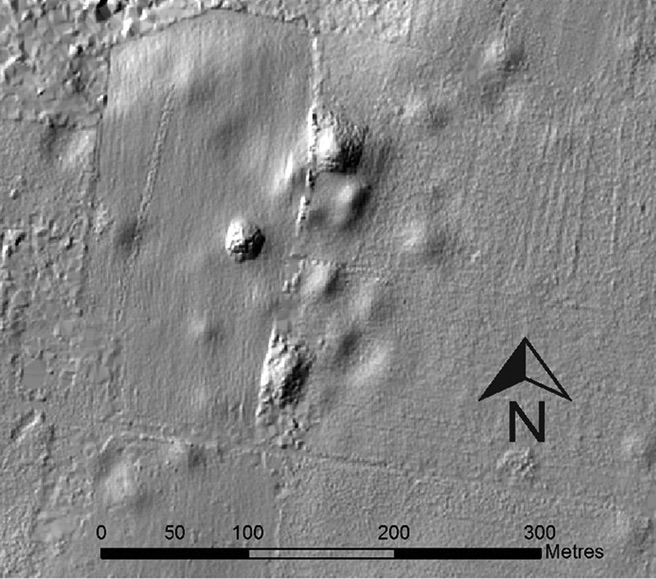
In a quest to understand the Izapa kingdom beyond the capital, Rosenswig and his colleagues started conducting surveys in the region on foot and with lidar, a remote-sensing technique.
A lidar instrument blasts rapid light pulses at a surface and measures how long it takes for the light to bounce back. Now that computing power has improved enough to handle the billions of points a lidar survey might collect, the technology has become a popular tool for archaeologists. A lidar survey that scans the landscape from a plane or drone allows researchers to "see" through vegetation to create a topographic map that can reveal lost roads, mounds, canals and other ancient human-made features.
Rosenswig said that one of his first surveys covered about 20 square miles (50 square kilometers) near Izapa. After he found nine small settlements in that area alone, he expanded the search. [10 Modern Tools for Indiana Jones]
Over a total area of 225 square miles (584 square km) —about the size of Chicago —Rosenswig documented 41 settlements around Izapa, all within about 13 miles (22 km) of the capital. The settlements varied in size, and the largest three seem to be arranged around the perimeter of the kingdom, likely offering a layer of protection from neighboring polities. (Carvings found in Izapa, some of which depict scenes of violence and decapitation, hint that there was conflict with other kingdoms.)
Get the world’s most fascinating discoveries delivered straight to your inbox.
The outlying towns followed the same blueprint. The east-west axis would have been aligned with the sunrise during winter solstice, Rosenswig said. The north-south axis was pointed just east of north, toward the Tacanávolcano (which eventually erupted and led to the downfall of the Izapa kingdom).
In the northern part of most of the sites, a pyramid stood on top of a platform that likely served as a stage for rituals and ceremonies. Then, to the south, the researchers found a few plazas formed by other mounds. This arrangement meant that a person standing in the middle of any of the outlying centers could look north and see the same thing: their town's stage with a pyramid, framing the same view, with the volcanoes in the Sierra Madre in the background.
The three largest second-tier sites, which probably had fewer than 2,000 residents, had at least one court in the south, where some variant of the Mesoamerican ball game was played. Those three settlements also had conical mounds that look like Maya complexes used for making astronomical observations.
"The fact that this structure was replicated at the lower-order centers, which are not that far apart, meant that there was this sense of polity in the Izapa kingdom, and being a member of this entailed some specific ritual activities that would have happened periodically," Rosenswig told Live Science.
Rosenswig and his co-author, a SUNY Albany remote-sensing specialist, Ricardo López-Torrijos, reported the findings Oct. 26 in the journal Antiquity.
"We knew that Izapa was a major site of monumental scale, but this article provides tangible evidence about the hinterland settlements in the region," said Oswaldo Chinchilla, an archaeologist at Yale University who studies ancient Mesoamerican societies and was not involved in the study. "Izapa emerges as the political and religious center of an early polity, whose early dating makes it significant for the study of the origins of the state in Mesoamerica."
Artifacts and carvings at the satellitesites could offer more clues about the relationship between the settlements. None of the three, second-tier centers have been excavated yet. Rosenswig said a future project will focus on a settlement where magnetometer and ground-penetrating radar surveys have already hinted at the presence of large stone sculptures buried underground.
Originally published on Live Science.

 Live Science Plus


