It's quick and easy to access Live Science Plus, simply enter your email below. We'll send you a confirmation and sign you up for our daily newsletter, keeping you up to date with the latest science news.
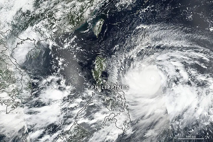
Typhoon Mangkhut as viewed by the the Visible Infrared Imaging Radiometer Suite (VIIRS) on the Suomi NPP satellite on Sept. 13, 2018. Typhoon Mangkhut is bearing down on the Philippines with 165 mph (270 km/hr) winds.
(Image credit: NASA Earth Observatory image by Lauren Dauphin, using VIIRS data from the Suomi National Polar-orbiting Partnership.)
As Hurricane Florence dumps rain on the Carolina coasts, another storm is spurring evacuations on the other side of the world.
Typhoon Mangkhut, also known as Typhoon Ompong, is set to batter the Philippines in the early morning of Sept. 15, local time. According to the Philippine Atmospheric, Geophysical and Astronomical Services Administration (PAGASA), the storm surge could reach 19 feet (6 meters) in some areas. [Hurricanes from Above: Images of Nature's Biggest Storms]
The Suomi NPP satellite captured this view of the monster storm on Sept. 13. At the time, the storm's sustained winds were topping out at 165 mph (270 km/h), which would put the storm at a Category 5 on the Saffir-Simpson Hurricane Wind Scale used in the U.S. (Hurricanes are spawned east of the international date line, whereas typhoons develop west of the line.)
Today (Sept. 14), the storm was still blowing with the same sustained wind speeds, along with gusts of up to 200 mph (320 km/h), according to the Joint Typhoon Warning Center in Hawaii. As of 7 p.m. local time (7 a.m. EDT), the storm was centered 162 miles (260 km) northeast of the Philippine municipality of Casiguran on the island of Luzon.
The typhoon is forecast to make landfall on Luzon in the early hours of Saturday, Sept. 15 local time (approximately 5 p.m. EDT on Sept. 14) before heading toward the southern coast of China for a second landfall late on Sept. 16 or early on Sept. 17 local time, according to the PAGASA.
Another satellite, NASA's Aqua satellite, captured an infrared image of Mangkhut on Sept. 13. The satellite's MODIS (Moderate Resolution Imaging Spectroradiometer)instrument uses infrared imagery to detect the temperatures of cloud tops. Around Mangkhut's eye, the data showed towering cloud tops as frigid as minus 80 degrees Fahrenheit (minus 62 degrees Celsius).
An infrared image of Typhoon Mangkhut taken on Sept. 13, 2018, by NASA's Aqua satellite, showing frigid cloud tops surrounding the eye of the storm.
(Image credit: NASA/NRL)
Thousands of people have evacuated coastal areas in Luzon ahead of the storm, according to CNN. The island is no stranger to devastating storms. In October 2016, Typhoon Haima made landfall in northern Luzon with Category 4-equivalent winds after a brief period at Category 5 strength. According to the National Disaster Risk Reduction and Management Council, Haima forced the evacuation of nearly 160,000 people and damaged more than 90,000 homes. Nineteen deaths were attributed to the storm, mostly the result of rain-triggered landslides.
Sign up for the Live Science daily newsletter now
Get the world’s most fascinating discoveries delivered straight to your inbox.
Stephanie Pappas is a contributing writer for Live Science, covering topics ranging from geoscience to archaeology to the human brain and behavior. She was previously a senior writer for Live Science but is now a freelancer based in Denver, Colorado, and regularly contributes to Scientific American and The Monitor, the monthly magazine of the American Psychological Association. Stephanie received a bachelor's degree in psychology from the University of South Carolina and a graduate certificate in science communication from the University of California, Santa Cruz.

 Live Science Plus