It's quick and easy to access Live Science Plus, simply enter your email below. We'll send you a confirmation and sign you up for our daily newsletter, keeping you up to date with the latest science news.
We live our whole lives wandering from one cloud of dust to the next. The air is full of the stuff: salt wafting in from the sea, black carbon soot from wildfires and all sorts of dusty emissions from heavy industry.
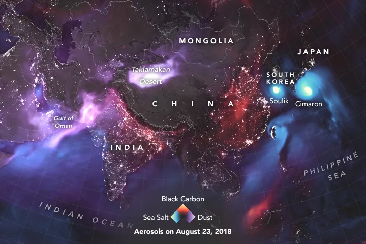
Usually, all that aerosolized gunk is invisible to us — but not to NASA's satellites and ground sensors. In a stunning new illustration, shown above, NASA's Earth Observatory reveals the invisible, tiny particles swirling around us.
NASA combined data from multiple sensors on satellites such as the Moderate Resolution Imaging Spectroradiometer (MODIS) sensors on Aqua and Terra, as well as ground based sensors, to create a colorized image of the aerosol plumes. [Earth Pictures: Iconic Images of Earth from Space]
Some of these dust clouds are the result of weather events. Hurricane Lane near Hawaii and typhoons Soulik and Cimaron off the coast of Japan have all kicked sea salt into the atmosphere. Over the Sahara Desert in northwest Africa and the Taklamakan Desert in northwest China, landlocked winds have similarly formed clouds of fine particles.
A full-globe image highlights all three major varieties of aerosol cloud.
(Image credit: NASA Earth Observatory)
Western North America and south-central Africa reveal signatures of another sort of aerosol: the smoke from wildfires, which are often set by humans — either intentionally, as part of annual agricultural cycles in Africa, or through carelessness as in North America. Some of that smoke from North America appears to have drifted east over the Atlantic Ocean in the image.
NASA noted that this image wasn't shot by a single camera and isn't even a composite of a group of images directly taken by satellites or ground sensors. Instead, NASA used some careful mathematics to bring together data from a range of different types of sources in order to figure out where the densest concentrations of loose particles in the atmosphere are right now.
Rafi joined Live Science in 2017. He has a bachelor's degree in journalism from Northwestern University’s Medill School of journalism. You can find his past science reporting at Inverse, Business Insider and Popular Science, and his past photojournalism on the Flash90 wire service and in the pages of The Courier Post of southern New Jersey.

 Live Science Plus