


Earth 'Breathes' in Amazing Time-Lapse Video from Space

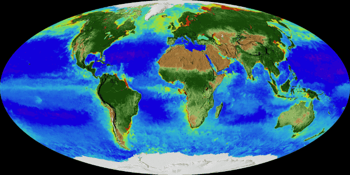
And now, data gathered by a fleet of satellites circling Earth since 1997 have been visualized as a breathtaking time-lapse video of our dynamic planet, capturing the most complete view to date of biology on a global scale, spanning two decades.
During warm months in each hemisphere, sea-ice cover near the poles declines and the lush green colors of emerging plant life spread in undulating waves over land, as more plants take up carbon dioxide and produce oxygen. In the oceans, microscopic phytoplankton swirl to form growing and shrinking clouds, likewise following seasonal cycles of growth that are visible to NASA satellites as subtle color changes in the water. [Earth Pictures: Iconic Images of Earth from Space]
"That's the Earth — that is it breathing every single day, changing with the seasons, responding to the sun, to the changing winds, ocean currents and temperatures," Gene Carl Feldman, an oceanographer at NASA's Goddard Space Flight Center in Greenbelt, Maryland, said in a statement.
"These are incredibly evocative visualizations of our living planet," Feldman said.
There's no question that the time-lapse video is mesmerizing to watch, but it also shows researchers something unprecedented, revealing the behavior of oceans and land simultaneously and through time, over decades.
"We've never had data like these before," Compton Tucker, an Earth scientist with NASA, said in a video statement.
"Half of our photosynthesis occurs in the oceans and the other half on land. And having these data to show both [sites of photosynthesis] at the same time — day after day, month after month, year after year for 20 years — is a great tool to study life on Earth," Tucker added.
Get the world’s most fascinating discoveries delivered straight to your inbox.
NASA experts compiled all this data from space to tell the fascinating visual story of the changes that happen on land and sea from season to season, creating a map that enables researchers to monitor ocean and forest health, and track conditions in fisheries and agriculture. As years tick by, larger-scale changes reveal how these cycles may be shifting in response to human activities that are reshaping the planet and its climate.
"You can see greening of the Arctic. You can see earlier summers, later winters," NASA oceanographer Jeremy Werdell said in a video statement.
"The view from space has opened our eyes to so many different things," Werdell said.
Continuous, global viewing of Earth's oceans began with the launch of the Sea-viewing Wide Field-of-view Sensor (SeaWiFS) satellite in 1997, and scientists were just in time to observe the transition from El Niño to La Niña — when tropical ocean temperatures in the Pacific shift from being warmer than average to being cooler than average.
That transition had a dramatic impact on phytoplankton growth, with plankton blooming in ocean regions where hardly any signs of planktonic life had been spied by satellites before.
"And we watched it happen in real time," Feldman said in the statement.
"For me, that was the first demonstration of the power of this kind of observation, to see how the ocean responds to one of the most significant environmental perturbations it could experience, over the course of just a few weeks," he said.
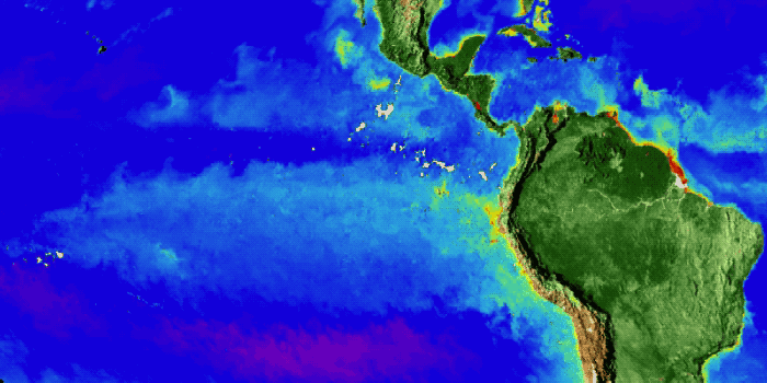
Certain patterns can also be observed over land, on a regional level. In the United States, for example, the recent impacts of drought in Texas, California and the Pacific Northwest are visible, while the southeastern part of the country has been spared extremes of dryness and flood. Consolidating this data from Earth-orbiting satellites helps scientists to better understand the interconnectedness of all these processes — in the oceans and on land, Fedldman said.
The fact that the time-lapse is beautiful and fascinating doesn't hurt either, Werdell added.
"The ability to expand your senses into space; compress time; watch visualizations like these; see how the ecosystems of land, sea, atmosphere, ice all interact; and then to be able to rewind it and watch it again and again — it's amazing," he said.
Original article on Live Science.

Mindy Weisberger is a science journalist and author of "Rise of the Zombie Bugs: The Surprising Science of Parasitic Mind-Control" (Hopkins Press). She formerly edited for Scholastic and was a channel editor and senior writer for Live Science. She has reported on general science, covering climate change, paleontology, biology and space. Mindy studied film at Columbia University; prior to LS, she produced, wrote and directed media for the American Museum of Natural History in NYC. Her videos about dinosaurs, astrophysics, biodiversity and evolution appear in museums and science centers worldwide, earning awards such as the CINE Golden Eagle and the Communicator Award of Excellence. Her writing has also appeared in Scientific American, The Washington Post, How It Works Magazine and CNN.