Hawaii's Big Island is being battered by heavy rainfall, wind and "catastrophic flooding" this morning (Aug. 24) as the entire state braces for the advance of Hurricane Lane, a Category 3 storm in the central Pacific Ocean with sustained winds of up to 120 mph (193 km/h), according to updates from the National Weather Service (NWS).
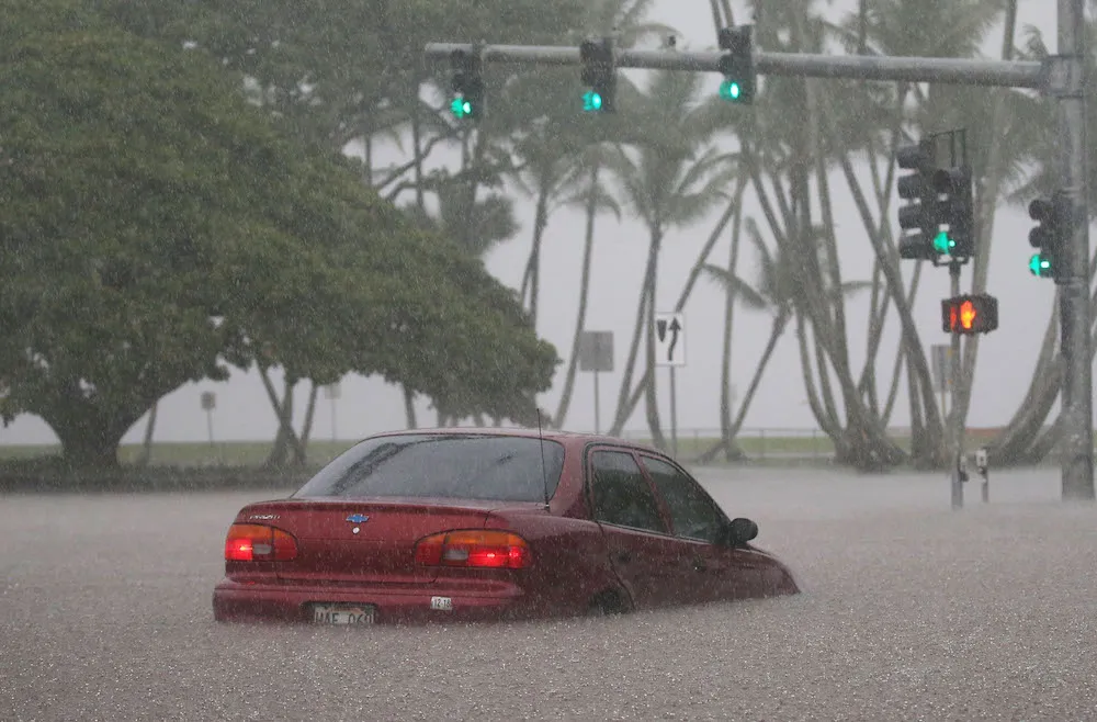
The NWS reported that parts of the Big Island are currently submerged in 2 feet (0.6 m) of rushing floodwater and that rain accumulation up to 40 inches (100 centimeters) is expected in some areas by the end of the weekend. As of 11 p.m. HST Thursday night (5 a.m. EDT on Friday), Hurricane Lane was located about 165 miles (265 kilometers) southwest of the town of Kailua-Kona (located on the west coast of the Big Island) and was creeping northward at about 6 mph (10 km/h).
The storm is expected to turn westward toward the other Hawaiian Islands on Saturday (Aug. 25), the NWS reported. [Hurricane Season 2018: How Long It Lasts and What to Expect]
Latest Videos From
"On the latest forecast track, the center of Lane will move over, or dangerously close to portions of the main Hawaiian islands later today through Saturday," The NWS reported Friday morning at 12:25 a.m. HST (6:25 a.m. EDT). "Regardless of the hurricane track, life threatening impacts will extend far beyond the center position of Lane."
Multiple highways on the Big Island were closed Thursday night (Aug. 23) due to flooding, landslides and fallen trees, and more than 260 residents and visitors have voluntarily evacuated to shelters. Hawaii Gov. David Ige told residents to avoid floodwaters and runoff "due to possible overflowing cesspools, sewer, manholes, pesticides, animal fecal matter, dead animals, pathogens, chemicals, and associated flood debris."
The storm is also expected to stir up "life-threatening surf" and dangerous rip currents along many of the state's exposed coastlines, the NWS reported. Waves as high as 10 to 15 feet (3 to 4.5 m) are predicted to hit the southwestern side of the Big Island today, while surf height will rise 15 to 25 feet (4.5 to 7.5 m) this afternoon in Maui County, Oahu and Kauai County.
Most of Hawaii's population lives on Oahu island, where Honolulu is located, according to NPR. Residents of Hawaii are advised to listen to local officials for instructions on evacuation throughout the weekend.
Originally published on Live Science.

 Live Science Plus