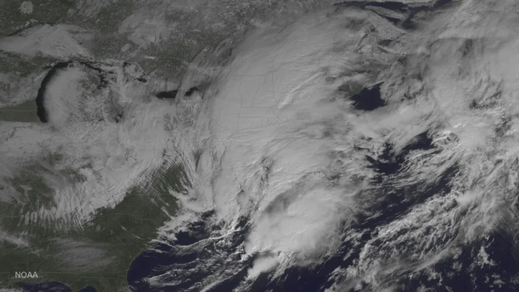
NEW YORK — As a winter storm blew over the northeastern United States today, a weather-monitoring satellite caught the whole storm on camera from space.
The GOES East weather satellite, jointly run by NASA and the National Oceanic and Atmospheric Administration (NOAA), hovers 22,300 miles (35,800 kilometers) above the Earth in a geostationary orbit, allowing it to keep constant tabs on the weather over North and South America.
GOES East (formerly known as GOES-13) takes measurements of different meteorological phenomena in Earth's atmosphere. NOAA combines those measurements with NASA's "Blue Marble" photos of Earth to create crisp, colorized images of the weather. [Earth from Space: Amazing GOES Satellite Views]
Winter storm Niko was blanketing the Northeast today (Feb. 9) with between 8 and 12 inches of snow, with some areas of New England expecting up to 18 inches (46 centimeters). The storm canceled thousands of flights and closed numerous schools and businesses in New York, Boston, Philadelphia and smaller communities. And the snow is still falling.
A statement issued by the National Weather Service this morning said that the "strong coastal winter storm will bring significant impacts to portions of the northern Middle Atlantic through northern New England Thursday into Thursday night. The potential exists for heavy snow and strong winds leading to dangerous travel conditions."
You live here, so we figure you ought to be well grounded in Earth facts. But you might find these questions a little tough and tricky. Good luck!
Earth Quiz: Do You Really Know Your Planet?
Sign up for the Live Science daily newsletter now
Get the world’s most fascinating discoveries delivered straight to your inbox.
Hanneke Weitering is an editor at Liv Science's sister site Space.com with 10 years of experience in science journalism. She has previously written for Scholastic Classroom Magazines, MedPage Today and The Joint Institute for Computational Sciences at Oak Ridge National Laboratory. After studying physics at the University of Tennessee in her hometown of Knoxville, she earned her graduate degree in Science, Health and Environmental Reporting (SHERP) from New York University. Hanneke joined the Space.com team in 2016 as a staff writer and producer, covering topics including spaceflight and astronomy.