
 Live Science Plus


Facts About Great Salt Lake
Great Salt Lake, in northern Utah, is the largest lake west of the Mississippi River and the largest salt lake in the Western Hemisphere. Sometimes referred to as America’s Dead Sea, it is nevertheless a critically important habitat for millions of native and migratory birds and is a federally managed bird refuge. It is also home to several types of algae, brine shrimp and brine flies.
Great Salt Lake contains several islands, causeways, a railroad, three state parks and an earthwork sculpture called the Spiral Jetty. The lake is a popular recreation area, with hiking, sailing and swimming available.
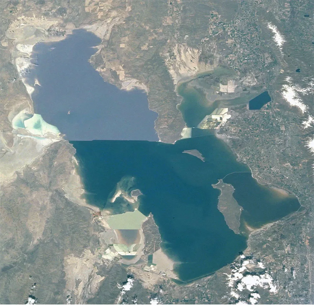
Dimensions
Great Salt Lake is typically bigger than the states of Delaware and Rhode Island, according to the U.S. Geological Survey (USGS). The size changes, however, as water levels rise and fall. The lake is only 14 feet (4 meters) deep on average so a foot of water loss can make a big difference in its total size.

These are the average dimensions of Great Salt Lake, according to USGS, Friends of Great Salt Lake, and the University of Utah.
- Surface area: 1,700 square miles (4,402 square kilometers) on an average year
- Length: 75 miles (120 km)
- Width: 28 miles (45 km)
- Average altitude of the water surface: 4,200 feet (1,280 meters)
- Maximum depth: 33 feet (10 m)
- Average depth: 14 feet (4 m)
- Total watershed area: 21,000 square miles (54389.75 square km), encompassing most of northern Utah and parts of Nevada, Idaho and Wyoming.
- Record high water level: In 1986, the altitude at the water surface was 4,212 feet (1,283 m) and the lake’s total surface area was 2,300 square miles (5,956 square km).
- Record low water level: In 1963, the altitude at the water surface was 4,191 feet (1,277 m) and the lake’s total surface area was 937 square miles (2,426 square km).
History
Great Salt Lake lies in a region of the Western United States called the Great Basin. The Wasatch Range rises to the east of the lake, with several 11,000-foot mountains. The Great Salt Lake Desert is west of the lake. It features a flat expanse of salt crust called the Bonneville Salt Flats, which has ideal conditions for attempts to break land-speed records.
The lake is a remnant of Lake Bonneville, an ancient, freshwater lake from the last Ice Age, said Bonnie Baxter, director of the Great Salt Lake Institute and a professor of biology at Westminster College in Salt Lake City. Lake Bonneville was 325 miles (523 km) long and 135 miles (217 km) wide and 1,000 feet (308 m) deep.
Lake Bonneville formed about 30,000 years ago from a small saline lake. Nearly 17,000 years ago, Lake Bonneville overflowed at Red Rock Pass in Idaho and a yearlong flood ensued. The lake lost about 375 feet (114 m) of water, according to the USGS. Lake Bonneville underwent several periods of shrinking and stabilizing. These changes were due to increased evaporation and a warming climate. There are four different shorelines visible as ridges on Utah’s Wasatch Mountains. The Bonneville Salt Flats in western Utah are a remnant of Lake Bonneville.
Get the world’s most fascinating discoveries delivered straight to your inbox.
The modern Great Salt Lake emerged about 10,000 years ago. Local Native American tribes knew about Great Salt Lake, of course. The first non-native person to see the lake is said to be explorer Jim Bridger in 1824, according to the Utah Geological Survey. The first thorough exploration of the lake was by a party led by John C. Fremont in 1843. On that expedition, Kit Carson visited one of the lake's islands and carved a cross near the summit of an island that is now called Fremont Island. Members of the Church of Jesus Christ of Latter-day Saints (or Mormons) arrived in the area in 1847 and used the islands for grazing cattle and also enjoyed swimming in the lake and holding picnics on its shores.
On May 10, 1869, the Transcontinental Railroad was completed on the Promontory Peninsula on the north end of Great Salt Lake. Though momentous, this wedding of the rails was not efficient; Great Salt Lake had caused the engineers to build a detour onto the rugged mountains of the peninsula. In 1902, the Southern Pacific built an east-west wooden railroad trestle across Great Salt Lake called the Lucien Cutoff, which bypassed Promontory Peninsula completely, according to American Rails. In 1959 the wooden trestle was replaced with a rock-fill causeway that is still in use today.
Salinity
As Lake Bonneville shrank, all of the minerals in it — including salt — concentrated into steadily less water. Every year, 2.2 million tons (1,814, 369 metric tons) of salt flows into Great Salt Lake from tributary rivers, according to USGS. “This accumulation of minerals and no outlet to the ocean results in a salt lake,” said Baxter.
“Terminal lakes are often salty,” she told Live Science. “Water evaporates, but salt stays behind and accumulates. A terminal lake holds everything that has ever entered the lake except water, which can leave by evaporation.”
Great Salt Lake is a sodium chloride lake, said Baxter. The hypersaline northern arm (also called Gunnison Bay) is about 30 percent salt. The southern portion of the lake (also called Gilbert Bay) fluctuates between 6 and 27 percent salinity. About 4.3 billion tons (3,628,738,960 metric tons) of salt are in Great Salt Lake.
As with many other saline lakes, including the Dead Sea, it is possible to float in Great Salt Lake.

Features
Great Salt Lake has three feeders: the Bear, Weber and Jordan rivers, according to Great Salt Lake Information System at Utah State University. These rivers carry fresh water from melted snow in the Wasatch Mountains into the eastern area of the lake. Sixty-six percent of fresh water entering the lake comes from these rivers. Additional fresh water comes from rainfall, groundwater and springs, according to Great Salt Lake Ecosystem Program. No feeders reach Gunnison Bay in the northwestern part of the lake. The western part of the Great Salt Lake watershed is desert and does not bring water into the lake except in very wet years.
There are 11 islands in Great Salt Lake, including the 28,800-acre (116 square km) Antelope Island, which is home to a state park and one of America’s largest free-roaming herds of bison, according to the Utah State Parks. Gunnison Island is home to a large population of pelicans. Several of the larger islands in the southern part of Great Salt Lake, including Antelope Island, become peninsulas when the water level is low. The Promontory Peninsula, home to the Golden Spike National Historic Site, divides Gunnison Bay from the rest of the northern area of the lake (also called Bear River Bay).
Willard Bay is a human-made freshwater reservoir on the northeastern flood plains of Great Salt Lake, according to Utah State Parks. The area was separated from Great Salt Lake in 1964 and is now a state park.
The Spiral Jetty is a massive earthwork sculpture on the northern shore of Great Salt Lake. Earthwork artist Robert Smithson built it in 1970. Smithson used more than 6,000 tons (5,443 metric tons) of black basalt rocks and earth dug up from the site to create a 1,500-foot-long (457 m) spiral that extends into the water, according to Dia Art. It is visible when the water level is below 4,197 feet (1,279 m) altitude.
The Union Pacific Railroad Northern Causeway is 21 miles (33 km) long and was built as a railroad shortcut. It divides Gunnison Bay, the northern arm of the lake, from Gilbert Bay in the south, according to Friends of Great Salt Lake. Human-built features like causeways and dykes impede water flow, which creates microenvironments, said Jaimi Butler, coordinator of the Great Salt Lake Institute. The clearest example of this is in the far north of the lake, where the Union Pacific Railroad Northern Causeway blocks freshwater flow and has created a super-saturation of salt and an extreme environment.
“Not many things live up there, and the microbes that do are pink or red,” said Butler. “Their red pigments help them deal with the harsh environment.” As a result, the water is often pink colored.
Mineral extractionis a major economic feature of Great Salt Lake, said Butler. According to USGS, five businesses extract salt and other minerals from the lake through solar evaporation ponds. No food-grade salt comes from the lake; Great Salt Lake salt is used for deicers, road salt, water softeners and salt licks for livestock. Additionally, said Butler, a massive brine shrimp harvest occurs every fall. The brine shrimp are primarily sent to Asia and South America where they are used as feeders for commercially grown prawn and fish.
Among Utah residents, Great Salt Lake is famous for occasionally emitting a stench like rotten eggs. It is caused by hydrogen sulfide, which certain species of bacteria in the lakebed breath out into the air. Though the smell annoys humans, Butler emphasized that it is just “microbes doing their job. They are transforming energy into some other form that is useful to the birds and the bugs.”
Oolitic sand is pill-shaped sand prevalent on the bottom of Great Salt Lake and several beaches. It is soft, smooth and round unlike regular sand that is jagged-edged, according to Great Salt Lake Ecosystem Program. A grain of oolitic sand begins as a brine shrimp fecal pellet or other small bit of debris. Calcium and magnesium carbonate particles build up around it, creating oolitic sand and separating brine shrimp waste from the rest of the water. In this way, oolitic sand functions as a filter for Great Salt Lake.
Ecosystem
Great Salt Lake has a vibrant and unique ecosystem. It is most famous as an important refuge for migrating birds. “Great Salt Lake is the largest inland body of water on the Pacific flyway,” explained Baxter. “This is a critical habitat for migrating birds to feed and grow in before they move on. There are only two invertebrates in the lake, brine shrimp and brine flies, but the numbers of these species provide an amazing amount of food for these birds.”
The size of its wetlands and the diversity of it aquatic environments also make Great Salt Lake appealing to many different bird species. Some are the American avocet, phalarope, bald eagle, barn owl, earned grebe, golden eagle, northern harrier and snowy plover, according to Great Salt Lake Marina.
“We have one of America’s largest pelican populations,” added Butler. “Pelicans eat fish but they nest in Gunnison Island, in the northern arm of the lake that has 10 times the amount of salt as the ocean. They nest there because it’s remote and there are no predators on the island.”
According to Great Salt Lake Ecosystem Program, more than 7.5 million birds in 257 species either stop at Great Salt Lake on their migrations of live at it, including one-third of the world’s population of phalaropes (500,000 birds).
Brine shrimp are the most populous animal in Great Salt Lake. These tiny crustaceans live in salt water around the world, but only one species, Artemia franciscana, lives in Great Salt Lake. They measure up to 0.5 inches (1.37 centimeters) long and can live in water with up to 33 percent salinity, according to Great Salt Lake Ecosystem Program. They can control how much salt gets into their body tissues better than any other organism on Earth due to skin lining their stomachs and gills. Scientists suspect that they originally came to Great Salt Lake as embryos in protective shells on the feet of migrating birds.
There are at least three species of brine flies that thrive at Great Salt Lake. Scientists estimate that there may be billions of brine flies swarming around the lake during the summer, according to Great Salt Lake Ecosystem Program. They are visible as swarms of tiny brown insects, but they do not bite. In their larval state, theyeat algae blooms in the water.
Threats
There are many threats to Great Salt Lake, said Butler, but by far the most pressing is water loss. Since 2011, Great Salt Lake has shrunk by almost 40 percent. In November 2016, NASA released satellite images demonstrating the decline. Approximately 50 percent of the lake bed is now exposed.
The West is in a drought cycle that, compounded by warming temperatures in Utah and surrounding states, results in less snowpack and precipitation, and, consequently less water entering Great Salt Lake through rivers, snowfall and rainfall, said Butler.
But local human activity plays a much bigger role in Great Salt Lake water loss. A 2016 white paper co-authored by Wayne Wurtsbaugh and published by the Utah State University describes how water flowing into the lake from rivers has been reduced by 39 percent in the last 150 years. Currently, about 40 percent of the river water is diverted and used for farming, industry and other forms of human consumption. According to Wurtsbaugh, human water use has lowered the lake level 11 feet (3.3 meters) in the last 10 years.
Water loss affects the entire ecosystem of Great Salt Lake. It increases salinity, which could impact brine shrimp and birds. Migrating fowl have fewer places to stay, as wetlands are desiccated. Butler noted the pelican population: “Pelicans nest on Gunnison Island because it has no predators, but when the water levels are too low, predators can walk out to the island.”
Additionally, said Butler, water loss impacts the salt and brine shrimp harvest economy. The tools aren’t built for low water levels. Lower lake levels also increase wind-blown dust, make the lake less accessible via boat and could have unforeseen effects on the Utah climate.
Humans also impact the lake through pollution. Great Salt Lake is unique among saline lakes in that it is next to a major metropolitan area, said Butler, and the Salt Lake City area is expected to double to 4 million people over the next 30 years. That proximity can cause problems, which are exacerbated by Great Salt Lake’s lack of outlet. “Everything that happens in the watershed and airshed [including pollution] can be seen in the lake,” said Butler. Rivers carry not only trash but toxins and other chemicals into Great Salt Lake. Polluted air brings in additional toxins.
But toxin problems don’t only come from local sources. According to the University of Utah Genetic Learning Science Center, Great Salt Lake has the highest levels of mercury of anywhere in the United States. Industry around the world emits mercury toxins, but they are benign in the atmosphere. Bacteria in Great Salt Lake turn it into toxic mercury.
Butler emphasized that the mercury exists primarily in a deep brine layer (about 19 feet or 6 meters down), which the regular water and brine does not penetrate. Therefore, it is safe for humans to swim in Great Salt Lake. Advisories have been issued for humans to avoid eating common goldeneye, cinnamon teal and northern shoveler duck caught around Great Salt Lake because of their mercury levels.
Additional resources
Jessie Szalay is a contributing writer to FSR Magazine. Prior to writing for Live Science, she was an editor at Living Social. She holds an MFA in nonfiction writing from George Mason University and a bachelor's degree in sociology from Kenyon College.