It's quick and easy to access Live Science Plus, simply enter your email below. We'll send you a confirmation and sign you up for our daily newsletter, keeping you up to date with the latest science news.
Looking for the Loch Ness monster just got easier, thanks to Google Street View.
In honor of the anniversary of a famous 1934 photograph of a mythical Scottish monster, the Internet search giant mapped out the iconic lake in all its panoramic glory. Viewers can explore above and below the surface of the lake, which extends about 23 miles (37 kilometers) southwest of the city of Inverness, connected to the River Oich to the south and the Bona Narrows to the north.
Though the views are spectacular, you're not likely to catch a glimpse of the Loch Ness monster. Called a living dinosaur by some, a sea serpent by others, "Nessie" has long been a part of Scottish folklore. According to Catholic legend, the creature was first sighted in A.D. 565, when St. Columba repelled a water beast after it had killed a man swimming in the Ness River leading into the lake. However, skeptics say the account is one of many Church myths about medieval saints battling monsters. [Loch Ness, Chupacabra & More: Our 10 Favorite Monsters]
Loch Ness in Scotland shown here in Google Street View.
(Image credit: Google Street View)
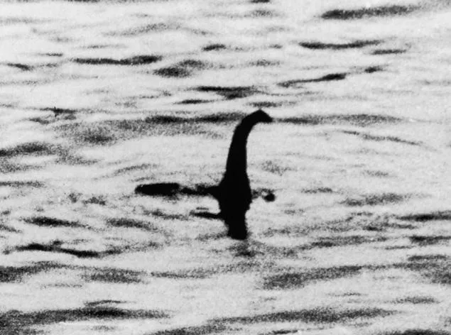
After that, no more sightings of the monster were reported for more than 1,000 years. In 1933, a photo taken by Hugh Gray and published in the local newspaper, The Inverness Courier, showed what some said was a long-tailed creature near the lake's surface, though the image was blurred by splashing. The following year, in April, the Daily Mail published the now-famous Surgeon's Photograph showing what appeared to be a monster's head and long neck poking out of the water. But the photo, taken by London surgeon Kenneth Wilson, was ultimately admitted to be a hoax.
While there have been dozens of alleged photos, films and videos of the elusive beast, no concrete evidence has emerged. But that hasn't stopped people from searching for it. In 2003, a research team funded by the BBC conducted one of the largest and most comprehensive searches of the lake, using sonar and satellite navigation, but found no signs of the creature.
Many of the supposed sightings can be explained by the mistaken appearance of birds, swimming deer, seals, waves and logs.
But even if it's a myth, the Loch Ness monster has become a magnet for tourism to the Scottish Highlands. And the lake itself is pretty impressive.Loch Ness is 754 feet (230 meters) deep, making it the second-deepest lake in Scotland after Loch Morar, which is 1,017 feet (310 m) deep and could fit the Eiffel Tower inside with 33 feet (10 m) to spare, according to a bathymetrical survey of Scotland's lakes conducted between 1897 and 1909.
Sign up for the Live Science daily newsletter now
Get the world’s most fascinating discoveries delivered straight to your inbox.
Loch Ness also holds more water than any other loch — about 263,162 million cubic feet (7,452 million cubic m) — followed by Loch Lomond (92,805 million cubic feet or 2,628 million cubic m) and Loch Morar (81,482 million cubic feet or 2,307 million cubic m), the survey found.
Tanya was a staff writer for Live Science from 2013 to 2015, covering a wide array of topics, ranging from neuroscience to robotics to strange/cute animals. She received a graduate certificate in science communication from the University of California, Santa Cruz, and a bachelor of science in biomedical engineering from Brown University. She has previously written for Science News, Wired, The Santa Cruz Sentinel, the radio show Big Picture Science and other places. Tanya has lived on a tropical island, witnessed volcanic eruptions and flown in zero gravity (without losing her lunch!). To find out what her latest project is, you can visit her website.

 Live Science Plus