Watch Carbon Pollution Spread Across the Planet

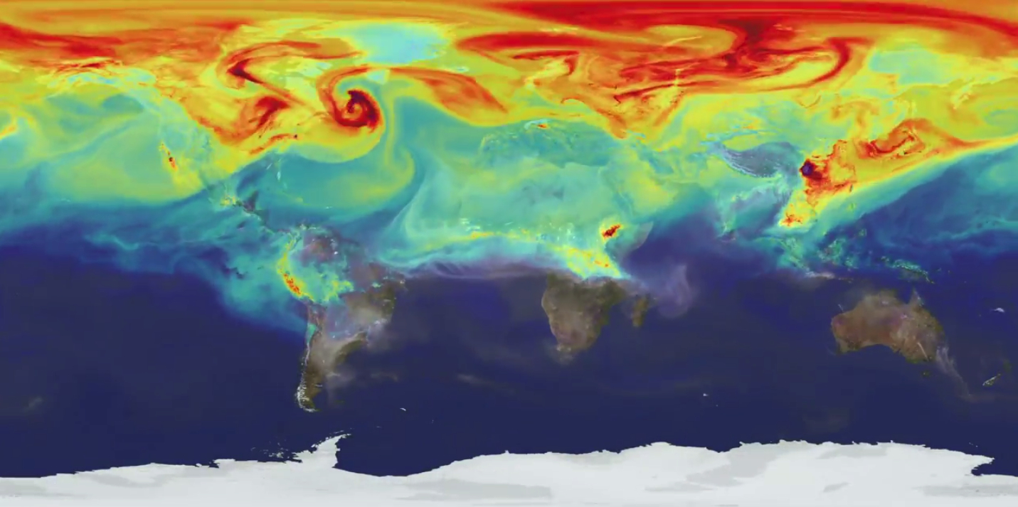
A striking new video from NASA reveals how the greenhouse gas carbon dioxide spreads across Earth in a single year.
The mesmerizing video was produced by a supercomputer model that took more than two months to run. Called GEOS-5, the model recreates the atmosphere's chaotic interplay among wind, weather and geography.
To show how carbon dioxide gas travels around the world, NASA scientists fed decades of weather and carbon dioxide data into the detailed computer model in a simulation called "Nature Run." The simulation includes carbon dioxide from both natural sources, such as volcanoes, and human-related emissions, such as those created during the burning of fossil fuels.
The results focus on a period between May 2005 and June 2007. At the time, carbon dioxide concentrations in the atmosphere ranged from 375 to 395 parts per million. Earlier this year, CO2 levels hit more than 400 parts per million for three months in a row. (That number means there were 400 molecules of carbon dioxide in the air for every 1 million air molecules.) [Watch: Time-Lapse Video of CO2 in Earth's Atmosphere]
In the simulation, the planet's three biggest polluters — the United States, China and Europe — are clearly pumping out plumes of carbon dioxide pollution. But the model also highlights the influence of seasonal cycles and local patterns on the amount of carbon dioxide in the atmosphere.
Earth's carbon dioxide levels peak in the spring, and then drop in summer, when Northern Hemisphere plant growth absorbs gas from the atmosphere. Concentrations rise again during fall and winter, continuing the cycle. Plant growth in the Northern Hemisphere has a greater effect on CO2 levels than it does in the Southern Hemisphere because there is more land in the Northern Hemisphere.
In North America, the major emissions sources are in the Midwest and along the East Coast. Westerly winds in the Gulf Stream carry the greenhouse gas eastward over the Atlantic Ocean, the model shows.
Get the world’s most fascinating discoveries delivered straight to your inbox.
In Asia, the Himalayas block and divert winds that swirl around the high mountains. East of the Himalayas, these winds pick up carbon dioxide emissions from the industrialized Asian countries and carry the gas toward the Pacific Ocean.
In the Southern Hemisphere, plumes of carbon dioxide and carbon monoxide rise from forest fires in South America and southern Africa.
"It's fascinating to see how local emission sources and weather systems produce gradients of [carbon dioxide] concentration on a very regional scale," Bill Putman, lead scientist on the project at NASA's Goddard Space Flight Center in Greenbelt, Maryland, said in a statement. "Simulations like this, combined with data from observations, will help improve our understanding of both human emissions of carbon dioxide and natural fluxes across the globe."
Follow Becky Oskin @beckyoskin. Follow Live Science @livescience, Facebook & Google+. Originally published on Live Science.

