It's quick and easy to access Live Science Plus, simply enter your email below. We'll send you a confirmation and sign you up for our daily newsletter, keeping you up to date with the latest science news.
Monsoon moisture will be on the increase across the Four Corners region this week, increasing the rain chances for the region and putting Phoenix at risk for another haboob.
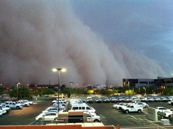
A haboob is a type of intense dust storm carried by strong winds that are usually the aftermath of a thunderstorm.
Recent thunderstorms that have dotted the Four Corners region have produced more dry lightning strikes than substantial rainfall.
That will change starting Tuesday when the door is opened for monsoon moisture to start streaming northward.
The initial surge of moisture will help ignite a cluster of thunderstorms across southeastern Arizona and southern New Mexico Tuesday afternoon.
The desert areas of southern Arizona, including Phoenix, may then become the target of a haboob Tuesday night as these thunderstorms track westward. Gusty winds racing away from the thunderstorms would trigger the massive dust storms.
Sign up for the Live Science daily newsletter now
Get the world’s most fascinating discoveries delivered straight to your inbox.
The added moisture in the air will also allow the thunderstorms to drop substantial rainfall Tuesday afternoon and night.
The same can be said across more of the Four Corners region as the week progresses and the monsoon moisture spills northward.
(Image credit: AccuWeather.com)
Significant rain-producing thunderstorms are definitely great news for a region where numerous wildfires are burning, but the welcome rain could come at a cost.
Too much rainfall in a short amount of time threatens to trigger flash flooding. Streams, creeks and arroyos could quickly turn into raging waterways.
Areas recently burned by wildfires are highly susceptible to not only flash flooding, but also mudslides with the severely charred soil not able to absorb the rain as quickly as normal.
Where the rain pours down on the burn areas in the mountains, the flooding rain and mud could flow down to impact the neighboring lower elevations.
Gusty winds racing away from the thunderstorms will not only be confined to the desert areas of Arizona but could also occur elsewhere across the Four Corners region. A shift or increase in wind where a wildfire is burning will create serious problems for firefighters.
AccuWeather.com meteorologists will also be monitoring the potential for some of the thunderstorms to turn severe with damaging winds.

 Live Science Plus