Western Wildfires Photographed from Space

Get the world’s most fascinating discoveries delivered straight to your inbox.
You are now subscribed
Your newsletter sign-up was successful
Want to add more newsletters?

Delivered Daily
Daily Newsletter
Sign up for the latest discoveries, groundbreaking research and fascinating breakthroughs that impact you and the wider world direct to your inbox.

Once a week
Life's Little Mysteries
Feed your curiosity with an exclusive mystery every week, solved with science and delivered direct to your inbox before it's seen anywhere else.

Once a week
How It Works
Sign up to our free science & technology newsletter for your weekly fix of fascinating articles, quick quizzes, amazing images, and more

Delivered daily
Space.com Newsletter
Breaking space news, the latest updates on rocket launches, skywatching events and more!

Once a month
Watch This Space
Sign up to our monthly entertainment newsletter to keep up with all our coverage of the latest sci-fi and space movies, tv shows, games and books.

Once a week
Night Sky This Week
Discover this week's must-see night sky events, moon phases, and stunning astrophotos. Sign up for our skywatching newsletter and explore the universe with us!
Join the club
Get full access to premium articles, exclusive features and a growing list of member rewards.
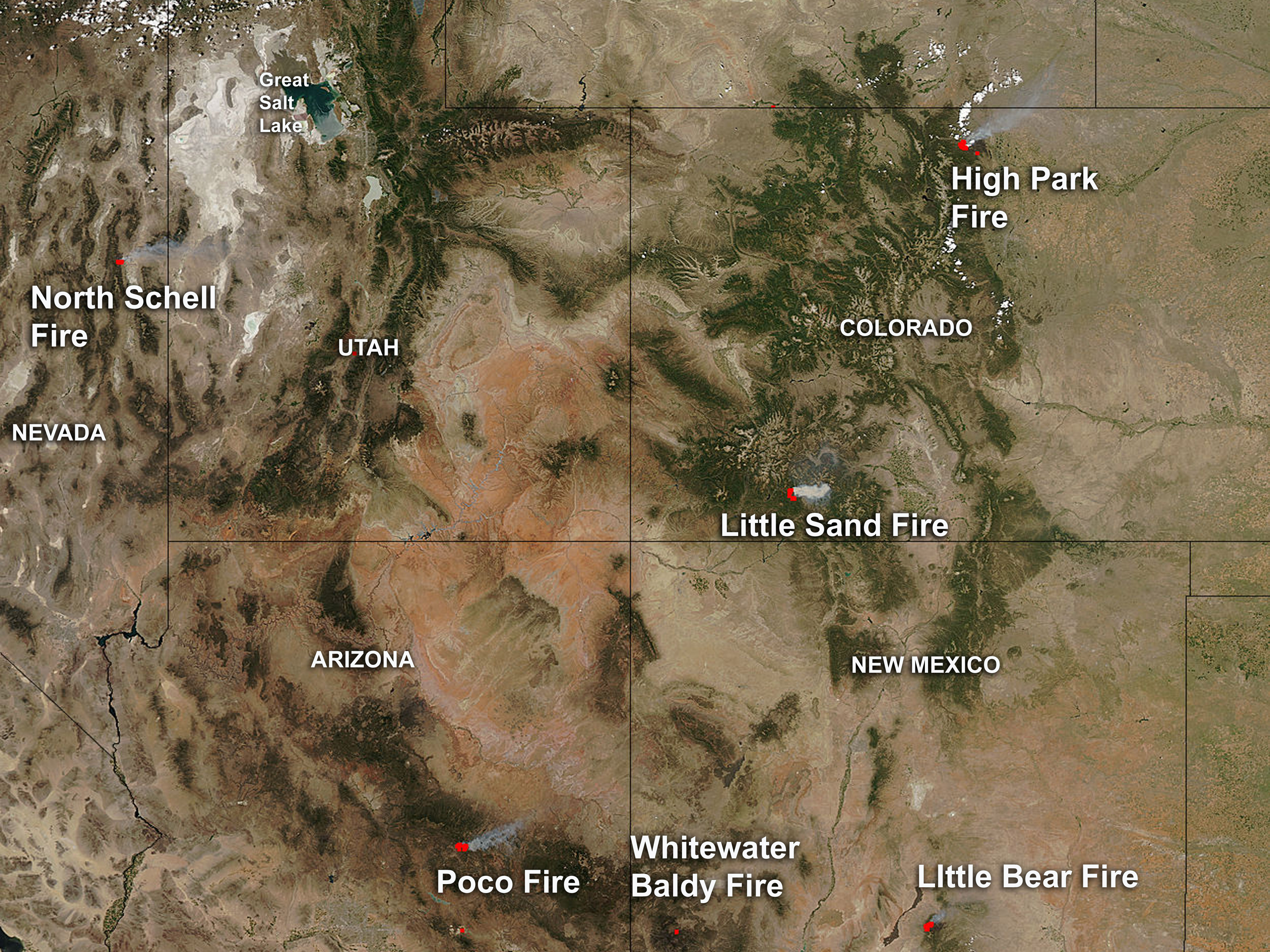
The many wildfires raging across the parched southwest United States can be seen in one view in this image taken by NASA's Aqua satellite on June 19.
The wildfires currently burning in the West include the High Park fire in Colorado, one of the costliest in the state's history. Centered to the west of Fort Collins, Colo., it has burned 130 square miles (337 square kilometers), according to InciWeb, the interagency system that tracks U.S. fire-related incidents. It has already cost nearly $30 million to put the fires out, and 2.2 million gallons (8.3 million liters) of water have been dropped on the fire, according to InciWeb. The fire was 45 percent contained as of this morning (June 25).
Colorado currently has more than half a dozen wildfires burning, the worst fire season for the state in more than a decade.
Meanwhile, New Mexico's Whitewater-Baldy fire continues to smolder. The largest wildfire in state history, it has chewed through 465 square miles (1,205 square km) of forest near Glenwood, N.M., since it was ignited by lightning on May 16.
Other, smaller fires are also visible in the image: The Little Bear Fire was started by lightning on June 4 near the town of Ruidoso, N.M., and has charred 69 square miles (179 square km). It is 90 percent contained. The Poco fire was started by a person on June 14 and has torched 19 square miles (48 square km) near Young, Ariz.
In southern Colorado, the Little Sand Fire is generating a thick plume of smoke in the Aqua satellite image. The fire is located 13 miles northwest of Pagosa Springs and has so far consumed 34 square miles (87 square km).
In Nevada, the North Schell Fire has consumed 19 square miles (49 square km). The fire began as a U.S. Forest Service prescribed burn on June 9.
Get the world’s most fascinating discoveries delivered straight to your inbox.
Red flag warnings are in effect across portions of 10 states, meaning "a combination of strong winds, low relative humidity and warm temperatures will create explosive fire growth potential," according to CNN.
Follow OurAmazingPlanet for the latest in Earth science and exploration news on Twitter @OAPlanet. We're also on Facebook and Google+.
 Live Science Plus


