Astronauts aboard the International Space Station have had a birds-eye view of the 2011 hurricane season, flying over and snapping pictures of several storms. Hurricane Katia is no exception, but luckily it isn't likely to cause much damage down on the ground.
"Hurricane Katia may be no threat to U.S., so just enjoy beauty of storm," tweeted astronaut Mike Fossum, who is living aboard the orbiting laboratory until mid-November.
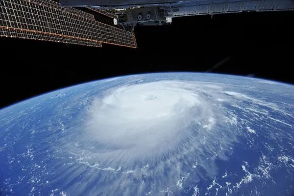
Fossum snapped a picture of the major Category 3 storm (on the Saffir-Simpson scale of hurricane strength), which has been swirling over the Atlantic Ocean for more than a week.
Latest Videos From
The most recent measurements of Katia showed that its winds had decreased to 120 mph (195 kph), and the storm is expected to fluctuate in strength over the next day or so, before weakening below major hurricane status around Thursday, according to the National Hurricane Center.
Despite early worries that Katia could deal the U.S. East Coast, still reeling from the impacts of Irene , another blow, the storm looks like it will churn up between the Eastern Seaboard and Bermuda before curving back out to sea. Katia isn't expected to directly threaten any land areas, though a tropical storm watch has been issued for Bermuda and surf conditions could be rough along the East Coast.
Hurricane Katia is the second hurricane to form during the 2011 hurricane season, which has been predicted to spawn an above-average 14 to 19 named storms (which include tropical storms and hurricanes), seven to 10 hurricanes and three to five major hurricanes. An average Atlantic hurricane season will see 11 named storms, six hurricanes and two major hurricanes. August through October are the peak months of the Atlantic hurricane season.