Hurricane Dora Packs a Punch
Get the world’s most fascinating discoveries delivered straight to your inbox.
You are now subscribed
Your newsletter sign-up was successful
Want to add more newsletters?
Delivered Daily
Daily Newsletter
Sign up for the latest discoveries, groundbreaking research and fascinating breakthroughs that impact you and the wider world direct to your inbox.
Once a week
Life's Little Mysteries
Feed your curiosity with an exclusive mystery every week, solved with science and delivered direct to your inbox before it's seen anywhere else.
Once a week
How It Works
Sign up to our free science & technology newsletter for your weekly fix of fascinating articles, quick quizzes, amazing images, and more
Delivered daily
Space.com Newsletter
Breaking space news, the latest updates on rocket launches, skywatching events and more!
Once a month
Watch This Space
Sign up to our monthly entertainment newsletter to keep up with all our coverage of the latest sci-fi and space movies, tv shows, games and books.
Once a week
Night Sky This Week
Discover this week's must-see night sky events, moon phases, and stunning astrophotos. Sign up for our skywatching newsletter and explore the universe with us!
Join the club
Get full access to premium articles, exclusive features and a growing list of member rewards.
Update 11:15 EDT: Hurricane Dora has been ungraded to a Category 4 storm, with winds of up to 155 mph (250 kph), which is nearly Category 5 strength, according to the National Hurricane Center.
Off the coast of southwestern Mexico, Dora strengthened to a Category 2 hurricane today (July 20).
Although the storm was headed out to sea, it had the potential to bring tropical storm conditions to parts of Mexico, and cause dangerous surf and rip current conditions.
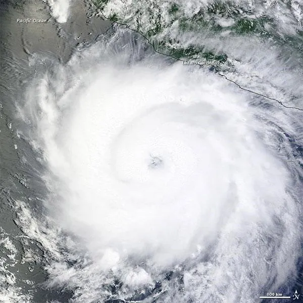
The Moderate Resolution Imaging Spectroradiometer (MODIS) on NASA's Terra satellite captured this natural-color image on July 20. Dora bears the spiral shape and distinct eye characteristic of strong storms. Dora's clouds graze Mexico's coast.
At 11:00 a.m. Pacific Daylight Time on July 20, the NHC reported that Dora had maximum sustained winds of 105 miles (165 kilometers) per hour with higher gusts. The storm was located roughly 215 miles (355 kilometers) south-southwest of Lázaro Cárdenas. The NHC forecast that Dora would travel a route nearly parallel to Mexico's southwestern coast over the next couple days.
- History of Destruction: 8 Great Hurricanes
- In the Eye of the Storm: NASA's Hurricane Hunters
- How Strong Can a Hurricane Get?
Get the world’s most fascinating discoveries delivered straight to your inbox.

