Tropical Storm Beatriz became Hurricane Beatriz last night as powerful thunderstorms roiling within the swirling cyclone warned of its potential power.
Beatriz was all but guaranteed to become a hurricane yesterday as the convection of the storms within it testified to its strengthening.
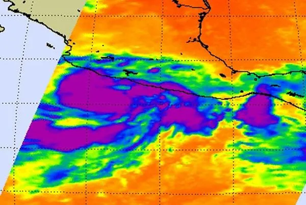
Infrared imagery on June 19-20 from the Atmospheric Infrared Sounder (AIRS) instrument that flies aboard NASA's Aqua satellite showed that cloud tops are cooling, indicating growing and higher thunderstorms. Typically, the higher the thunderstorm, the stronger the storm.
Latest Videos From
By June 20 at 08:11 UTC (4:11 a.m. EDT) the AIRS instrument showed a more rounded and organized circulation with strong convection. Meteorologists at the National Hurricane Center use this data with other satellite data in their forecasts.
Following the predictions, Beatriz was a hurricane as of 8:00 p.m. PDT last night (June 20). As of this morning (June 21), Beatriz had maximum wind speeds of 90 mph (150 kph), making it a Category 1 storm on the Saffir-Simpson scale of hurricane strength.
The storm is skirting along the west coast of Mexico, and a hurricane warning is in effect for portions of the coast. The storm could bring rains totaling 6 to 12 inches (15 to 30 cm). Storm surge could also hit portions of the coast.
Beatriz is expected to move northwestward today and will likely weaken again as it moves over cooler Pacific waters, which cut off the fuel source of tropical cyclones, the generic name for hurricanes, tropical storms and typhoons.
Beatriz formed from the low pressure area System 92E. On June 19 at 11 a.m. EDT it became tropical depression two-E. Just three hours later it reached tropical storm strength and was named Beatriz. It is the second hurricane of the eastern Pacific season -- Hurricane Adrian was the first. No hurricanes have yet formed in the Atlantic basin.

 Live Science Plus