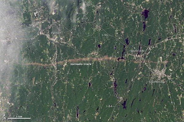
On June 1, 2011, a supercell thunderstorm developed over western Massachusetts. The storm produced an EF3 tornado that cut a 39-mile (63-kilometer) track of destruction across southwest and south-central Massachusetts.
Not only did the long-lived tornado remain on the ground for many miles, but it also widened to 0.5 miles (0.8 kilometers).
The Thematic Mapper on the Landsat 5 satellite captured this natural-color image of the tornado's path of destruction on June 5, 2011.
Latest Videos From
According to the Boston Globe, Massachusetts state police reported a tornado on the ground in the town of Sturbridge at 5:22 p.m. The tornado was spotted on the Interstate 84 exit, and cars were overturned.
Tornadoes on June 1 killed at least four residents of the state, as well as reducing homes, schools, and churches to rubble. The twister was the deadliest to hit the state in 16 years; the last deadly tornado to hit Massachusetts was an EF-4 that struck on May 29, 1995 and killed three people in the town of North Egremont.
This tornado season has been one for the record books, with more than 500 tornado-related deaths and several storms rated EF-5s, the highest rating on the tornado damage scale .

 Live Science Plus